Tell, Nablus
Tell | |
|---|---|
| Arabic transcription(s) | |
| • Arabic | تلّ |
| • Latin | Tel (official) Tall (unofficial) |
| Tell Tell | |
| Lua error in Module:Location_map at line 411: Malformed coordinates value. | |
| Coordinates: Lua error in Module:Coordinates at line 489: attempt to index field 'wikibase' (a nil value). | |
| Palestine grid | 170/178 |
| State | State of Palestine |
| Governorate | Nablus |
| Government | |
| • Type | Village council |
| • Head of Municipality | Omar Abdel Latif Eshtaia |
| Area | |
• Total | 13.8 km2 (5.3 sq mi) |
| Population (2017)[1] | |
• Total | 5,162 |
| • Density | 374/km2 (969/sq mi) |
| Name meaning | "Mound"[2] |

Tell (Arabic: تلّ), pronounced Till, is a Palestinian town in the Nablus Governorate in northern West Bank, located five kilometers southwest of Nablus. According to the Palestinian Central Bureau of Statistics (PCBS), the town had a population of 5,162 inhabitants in 2017.[1] Most of the town's laborers work in agriculture, with figs and olives being the major source of income.[3]
Mohammad Shtayyeh, a Palestinian economist and politician, was born in Tell.
History
[edit | edit source]Ceramics from the Byzantine era have been found here.[4]
Ottoman era
[edit | edit source]In 1517, the village was included in the Ottoman Empire with the rest of Palestine, and it appeared in the 1596 tax-records as Till, located in the Nahiya of Jabal Qubal of the Liwa of Nablus. The population was 46 households, all Muslim. They paid a fixed tax rate of 33.3% on agricultural products, such as wheat, barley, summer crops, olive trees, goats and beehives, in addition to occasional revenues, a press for olive oil or grape syrup, and a fixed tax for people of Nablus area; a total of 5,100 akçe.[5]
In 1838, Till was located in the District of Jurat 'Amra, south of Nablus.[6]
In 1863, Victor Guérin found it to have a population of one thousand inhabitants. It was divided into several districts, each administered by a different sheikh. He further noted: "Some houses are large and fairly well built. Around the village grow, in pens, beautiful plantations of fig and pomegranate trees."[7]
In 1870/1871 (1288 AH), an Ottoman census listed the village in the nahiya (sub-district) of Jamma'in al-Thani, subordinate to Nablus.[8]
In 1882, the PEF's Survey of Western Palestine described Till as: "A village of moderate size on low ground, with a high mound behind it on the south; it has a well and a few trees, and on the west a pool in winter; the hills to the north are bare and white, but terraced to the very top."[9]
British mandate era
[edit | edit source]In the 1922 census of Palestine conducted by the British Mandate authorities, Tel had a population of 567 Muslims,[10] increasing in the 1931 census to 803 Muslims, in 209 houses.[11]
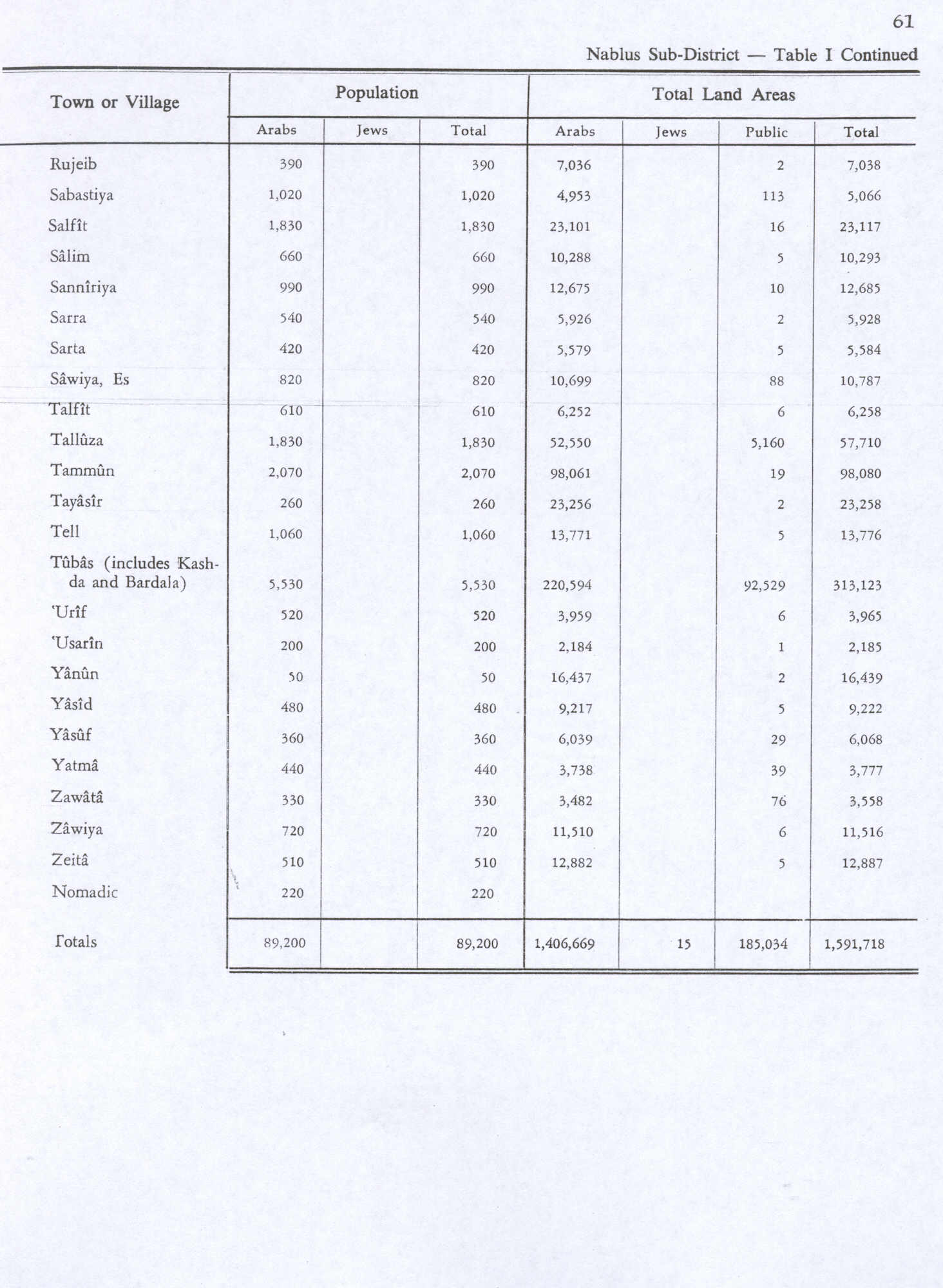
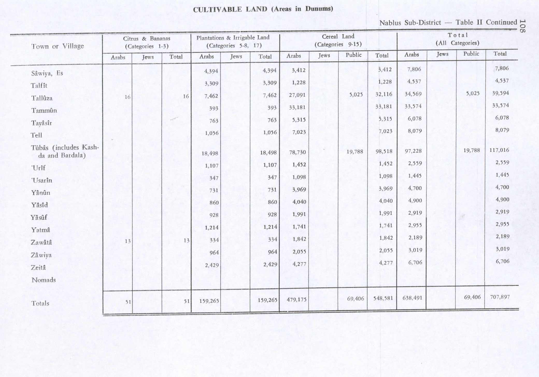
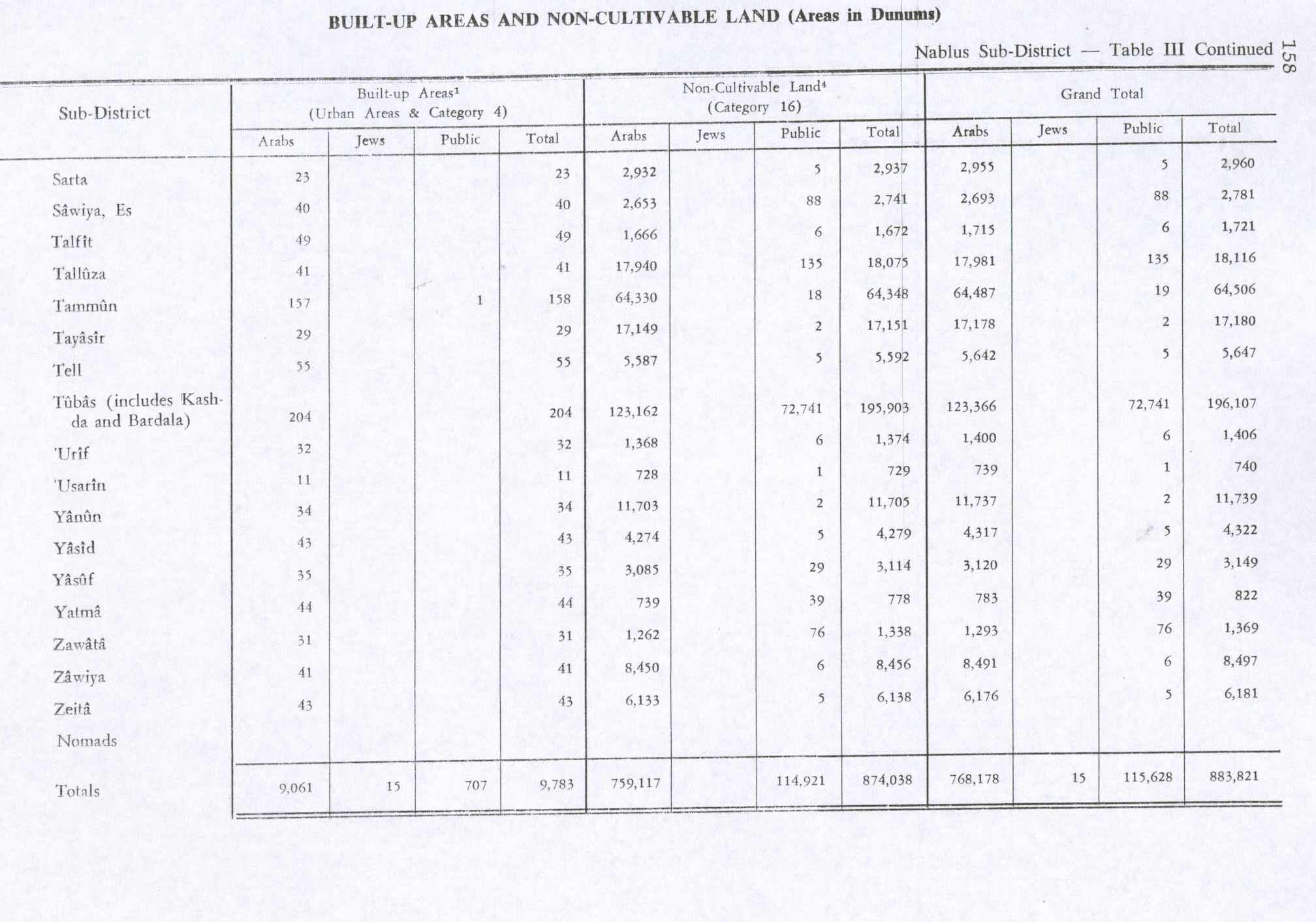
In the 1945 statistics the population was 1,060 Muslims,[12] while the total land area was 13,766 dunams, according to an official land and population survey.[13] Of this, 1,056 dunams were for plantations and irrigable land, 7,023 for cereals,[14] while 55 dunams were classified as built-up areas.[15]
Jordanian era
[edit | edit source]In the wake of the 1948 Arab–Israeli War, and after the 1949 Armistice Agreements, Tell came under Jordanian rule.
The Jordanian census of 1961 found 1,539 inhabitants.[16]
1967, aftermath
[edit | edit source]Since the Six-Day War in 1967, Tell has been held under Israeli military occupation.
References
[edit | edit source]- ^ a b Lua error in Module:Citation/CS1/Configuration at line 2172: attempt to index field '?' (a nil value).
- ^ Palmer, 1881, p. 194
- ^ Israeli Forces Storm Tel village In Nablus Governorate Archived 2011-05-19 at the Wayback Machine Land Research Center. 2001-12-20
- ^ Dauphin, 1998, p. 798
- ^ Hütteroth and Abdulfattah, 1977, p. 134
- ^ Robinson and Smith, 1841, vol 3, Appendix 2, p. 127
- ^ Guérin, 1875, p. 178
- ^ Lua error in Module:Citation/CS1/Configuration at line 2172: attempt to index field '?' (a nil value).
- ^ Conder and Kitchener, 1882, SWP II, p. 164
- ^ Barron, 1923, Table IX, p. 24
- ^ Mills, 1932, p. 65
- ^ Government of Palestine, Department of Statistics, 1945, p. 19
- ^ Government of Palestine, Department of Statistics. Village Statistics, April, 1945. Quoted in Hadawi, 1970, p. 61
- ^ Government of Palestine, Department of Statistics. Village Statistics, April, 1945. Quoted in Hadawi, 1970, p. 108
- ^ Government of Palestine, Department of Statistics. Village Statistics, April, 1945. Quoted in Hadawi, 1970, p. 158
- ^ Government of Jordan, Department of Statistics, 1964, p. 24

Bibliography
[edit | edit source]- Lua error in Module:Citation/CS1/Configuration at line 2172: attempt to index field '?' (a nil value).
- Lua error in Module:Citation/CS1/Configuration at line 2172: attempt to index field '?' (a nil value).
- Lua error in Module:Citation/CS1/Configuration at line 2172: attempt to index field '?' (a nil value).
- Lua error in Module:Citation/CS1/Configuration at line 2172: attempt to index field '?' (a nil value).
- Lua error in Module:Citation/CS1/Configuration at line 2172: attempt to index field '?' (a nil value).
- Lua error in Module:Citation/CS1/Configuration at line 2172: attempt to index field '?' (a nil value).
- Lua error in Module:Citation/CS1/Configuration at line 2172: attempt to index field '?' (a nil value).
- Lua error in Module:Citation/CS1/Configuration at line 2172: attempt to index field '?' (a nil value).
- Lua error in Module:Citation/CS1/Configuration at line 2172: attempt to index field '?' (a nil value).
- Lua error in Module:Citation/CS1/Configuration at line 2172: attempt to index field '?' (a nil value).
- Lua error in Module:Citation/CS1/Configuration at line 2172: attempt to index field '?' (a nil value).
External links
[edit | edit source]- Welcome to Tall
- Survey of Western Palestine, Map 11: IAA, Wikimedia commons
- Tell, aerial photo, Applied Research Institute–Jerusalem (ARIJ)


