Qusin
Qusin | |
|---|---|
| Arabic transcription(s) | |
| • Arabic | قوصين |
| Qusin, from the south Qusin, from the south | |
| Lua error in Module:Location_map at line 411: Malformed coordinates value. | |
| Coordinates: Lua error in Module:Coordinates at line 489: attempt to index field 'wikibase' (a nil value). | |
| Palestine grid | 167/182 |
| State | State of Palestine |
| Governorate | Nablus |
| Government | |
| • Type | Village council |
| Population (2017)[1] | |
• Total | 2,251 |
| Name meaning | The two cloisters[2] |

Qusin (Arabic: قوصين) is a Palestinian town in the Nablus Governorate in northern West Bank, located 8 kilometers West of Nablus. According to the Palestinian Central Bureau of Statistics (PCBS), the town had a population of 2,251 inhabitants in 2017.[1]
Location
[edit | edit source]Qusin is located 7.7 km west of Nablus. It is bordered by Beit Iba to the east, Deir Sharaf to the north, Kafr Qaddum to the west, and Kafr Qaddum and Jit to the south.[3]
History
[edit | edit source]Ceramics from the Byzantine era have been found here.[4]
Yaqut (1179–1229) described Kusin as a "Village in the Filastin Province, so I believe."[5]
Ottoman era
[edit | edit source]Qusin, like the rest of Palestine, was incorporated into the Ottoman Empire in 1517, and in the census of 1596 it was a part of the nahiya ("subdistrict") of Jabal Sami which was under the administration of the liwa ("district") of Nablus. The village had a population of 15 households and 7 bachelors, all Muslim. The villagers paid a fixed tax-rate of 33,3% on agricultural products, such as wheat, barley, summer crops, beehives and/or goats, in addition to occasional revenues and a customary tax for people of Nablus area; a total of 6,300 akçe.[6]
In 1870/1871 (1288 AH), an Ottoman census listed the village in the nahiya (sub-district) of Wadi al-Sha'ir.[7]
In 1882, in the PEF's Survey of Western Palestine, Kusein was described as: "A village on the side of a ridge, apparently supplied by the water of the valley on the north, which has a flowing stream. A spring exists about three-quarters of a mile south-east in the valley."[8] They further noted that: "The ruin shown near this place is merely a heap of stones."[9]
British Mandate era
[edit | edit source]_01.jpg)
In the 1922 census of Palestine conducted by the British Mandate authorities, Qusen had a population of 147 Muslims,[10] increasing in the 1931 census to 217 Muslims, in 48 houses.[11]
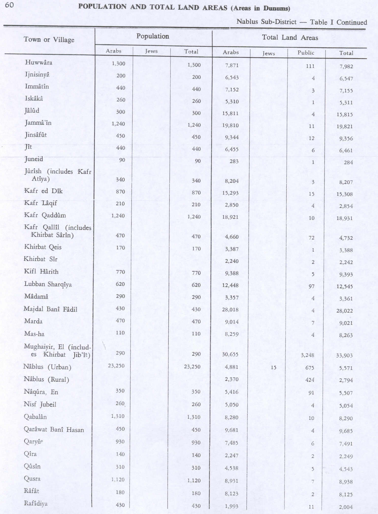
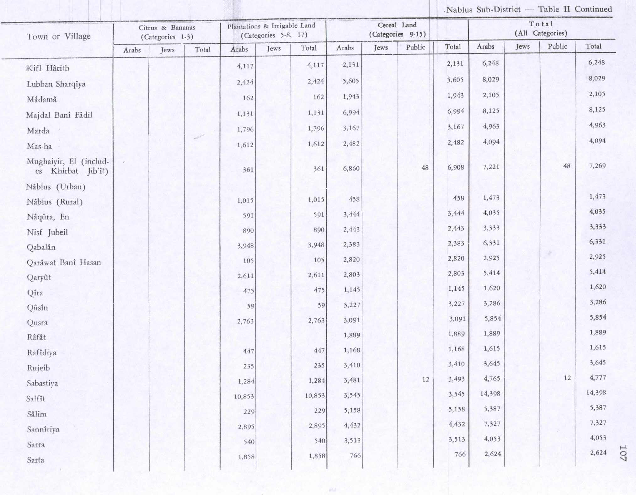
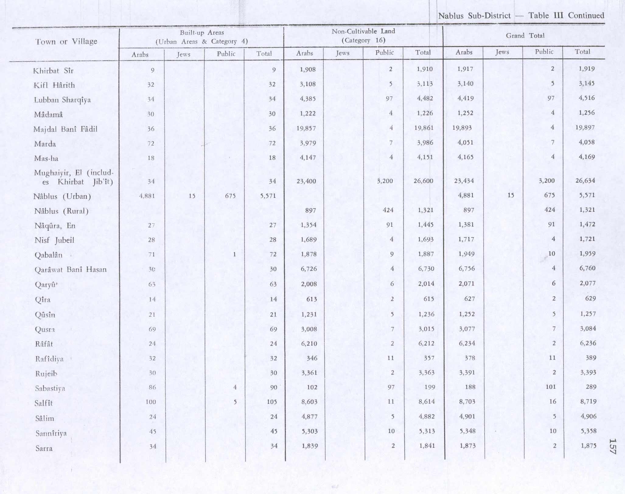
In the 1945 statistics, Qusin had a population of 310 Muslims[12] while the total land area was 4,543 dunams, according to an official land and population survey.[13] Of this, 59 dunams were used for plantations and irrigable land, 3,227 for cereals,[14] while 21 dunams were classified as built-up areas.[15]
Jordanian era
[edit | edit source]In the wake of the 1948 Arab–Israeli War, and after the 1949 Armistice Agreements, Qusin came under Jordanian rule.
The Jordanian census of 1961 found 494 inhabitants.[16]
Post 1967
[edit | edit source]After the Six-Day War in 1967, Qusin came under Israeli occupation.
After the 1995 accords 51% of village land is defined as Area B land, while the remaining 49% is defined as Area C. Israel has confiscated about 500 dunham of village land for future expansion of Israeli settlements, and additional land for Israeli bypass roads.[17]
Demography
[edit | edit source]Local origins
[edit | edit source]Some of Qusin's residents have their origins in Ramin and Kafr Qaddum.[18]
References
[edit | edit source]- ^ a b Lua error in Module:Citation/CS1/Configuration at line 2172: attempt to index field '?' (a nil value).
- ^ Palmer, 1881, p. 187
- ^ Qusin Village Profile, ARIJ, p. 4
- ^ Dauphin, 1998, p.771
- ^ Le Strange, 1890, p. 490
- ^ Hütteroth and Abdulfattah, 1977, p. 129
- ^ Lua error in Module:Citation/CS1/Configuration at line 2172: attempt to index field '?' (a nil value).
- ^ Conder and Kitchener, 1882, SWP II, p. 160
- ^ Conder and Kitchener, 1882, SWP II, p. 201
- ^ Barron, 1923, Table IX, p. 24
- ^ Mills, 1932, p. 64
- ^ Government of Palestine, Department of Statistics, 1945, p. 19
- ^ Government of Palestine, Department of Statistics. Village Statistics, April, 1945. Quoted in Hadawi, 1970, p. 60
- ^ Government of Palestine, Department of Statistics. Village Statistics, April, 1945. Quoted in Hadawi, 1970, p. 107
- ^ Government of Palestine, Department of Statistics. Village Statistics, April, 1945. Quoted in Hadawi, 1970, p. 157
- ^ Government of Jordan, Department of Statistics, 1964, p. 26
- ^ Qusin Village Profile, ARIJ, pp. 16-17
- ^ Grossman, D. (1986). "Oscillations in the Rural Settlement of Samaria and Judaea in the Ottoman Period". in Shomron studies. Dar, S., Safrai, S., (eds). Tel Aviv: Hakibbutz Hameuchad Publishing House. p. 353

Bibliography
[edit | edit source]- Lua error in Module:Citation/CS1/Configuration at line 2172: attempt to index field '?' (a nil value).
- Lua error in Module:Citation/CS1/Configuration at line 2172: attempt to index field '?' (a nil value).
- Lua error in Module:Citation/CS1/Configuration at line 2172: attempt to index field '?' (a nil value).
- Lua error in Module:Citation/CS1/Configuration at line 2172: attempt to index field '?' (a nil value).
- Lua error in Module:Citation/CS1/Configuration at line 2172: attempt to index field '?' (a nil value).
- Lua error in Module:Citation/CS1/Configuration at line 2172: attempt to index field '?' (a nil value).
- Lua error in Module:Citation/CS1/Configuration at line 2172: attempt to index field '?' (a nil value).
- Lua error in Module:Citation/CS1/Configuration at line 2172: attempt to index field '?' (a nil value).
- Lua error in Module:Citation/CS1/Configuration at line 2172: attempt to index field '?' (a nil value).
- Lua error in Module:Citation/CS1/Configuration at line 2172: attempt to index field '?' (a nil value).
External links
[edit | edit source]- Welcome to Qusin
- Survey of Western Palestine, Map 11: IAA, Wikimedia commons
- Qusin Village Profile, Applied Research Institute–Jerusalem (ARIJ)
- Qusin, aerial photo, ARIJ
- Development Priorities and Needs in Qusin, ARIJ


