Weiler-Simmerberg
This article needs additional citations for verification. (March 2007) |
Weiler-Simmerberg | |
|---|---|
 Weiler-Simmerberg Town Hall | |
 Coat of arms | |
Location of Weiler-Simmerberg
within Lindau district 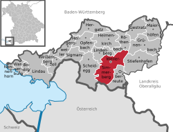 | |
| Lua error in Module:Infobox_mapframe at line 197: attempt to index field 'wikibase' (a nil value). | |
| Lua error in Module:Location_map at line 411: Malformed coordinates value. | |
| Coordinates: Lua error in Module:Coordinates at line 489: attempt to index field 'wikibase' (a nil value). | |
| Country | Germany |
| State | Bavaria |
| Admin. region | Schwaben |
| District | Lindau |
| Government | |
| • Mayor (2020–26) | Tobias Paintner[1] |
| Area | |
• Total | 31.30 km2 (12.08 sq mi) |
| Highest elevation | 900 m (3,000 ft) |
| Lowest elevation | 630 m (2,070 ft) |
| Population (Lua error in Module:Settlement_Wikidata at line 197: attempt to index field 'wikibase' (a nil value).)Lua error in Module:Settlement_Wikidata at line 197: attempt to index field 'wikibase' (a nil value). | |
• Total | Lua error in Module:Settlement_Wikidata at line 197: attempt to index field 'wikibase' (a nil value). |
| Time zone | UTC+01:00 (CET) |
| • Summer (DST) | UTC+02:00 (CEST) |
| Postal codes | 88171 |
| Dialling codes | 08387 (Weiler-Simmerberg) 08384 (Ellhofen) |
| Vehicle registration | LI |
Weiler-Simmerberg is a market town in the Swabian Lindau district.
Geography
[edit | edit source]Being located in the Westallgäu, the market town is bordering on the region of the Bregenz Forest, part of the Austrian administrative region of Vorarlberg. The Hausbachklamm belongs to the prominent landmarks and sights of Weiler-Simmerberg, as well as the Enschenstein and the Wildrosenmoos. Even though the landscape is rather mild, there are many very cliffy and steep rock faces due to the irregular bedding of sandstone and conglomerate.
Parts of the municipality
[edit | edit source]The area of Weiler-Simmerberg consists of the "Gemarkungen" Ellhofen, Simmerberg and Weiler im Allgäu.
The following districts belong to the market town of Weiler-Simmerberg:
|
|
History
[edit | edit source]
The municipality celebrated the 1111th anniversary of its first mentioning in 2005. The market town of Weiler-Simmerberg had been seat of a higher and lower court before 1805 and belonged to the Austrian authority of Bregenz-Hohenegg. Since the signing of the peace treaties of Brünn und Preßburg in 1805, the town belongs to Bavaria. In the course of the administrative reforms in Bavaria, the contemporary municipality was formed by the "Gemeindeedikt" of 1818.
Twin towns
[edit | edit source]Weiler-Simmerberg is twinned with:
References
[edit | edit source]Towns and municipalities in Lindau (district) | ||
|---|---|---|
 | ||
Lua error in Module:Authority_control at line 153: attempt to index field 'wikibase' (a nil value).