Treptow
Jump to navigation
Jump to search
| Sign | Map |
|---|---|

|
Error creating thumbnail: |
| Area: | 40.65 km2 |
| Inhabitants: | 113,140 (1999) |
| Population density: | 2783 inhabitants per km2 |
| Politics | |
| Status: | Disestablished as borough with the 2001 administrative reform |
| Last mayor: | Siegfried Stock (SPD) |
Treptow (German pronunciation: [ˈtʁeːptoː] <phonos file="De-Treptow.ogg"></phonos>) was a former borough in the southeast of Berlin. It merged with Köpenick to form Treptow-Köpenick in 2001.
Geography
[edit | edit source]The district was composed by the localities of Alt-Treptow, Plänterwald, Baumschulenweg, Niederschöneweide, Johannisthal, Adlershof, Altglienicke and Bohnsdorf.
Photo gallery
[edit | edit source]-
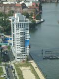 Twin Towers building in Treptow
 -
 Treptowers compound in Treptow
 -
 People sunbathing along the Spree River in Treptow


See also
[edit | edit source]Lua error in mw.title.lua at line 392: bad argument #2 to 'title.new' (unrecognized namespace name 'Portal').
External links
[edit | edit source]- Error creating thumbnail: File missing Media related to Lua error in Module:Commons_link at line 62: attempt to index field 'wikibase' (a nil value). at Wikimedia Commons
- File:Wikivoyage-Logo-v3-icon.svg Treptow travel guide from Wikivoyage
Lua error in Module:Coordinates at line 489: attempt to index field 'wikibase' (a nil value). Lua error in Module:Authority_control at line 153: attempt to index field 'wikibase' (a nil value).