Storglomvatnet
Jump to navigation
Jump to search
| File:Storglomvatnet from Holmvassdammen.JPG | |
| Location | Meløy Municipality, Nordland |
| Coordinates | Lua error in Module:Coordinates at line 489: attempt to index field 'wikibase' (a nil value). |
| Basin countries | Norway |
| Max. length | 12 kilometres (7.5 mi) |
| Max. width | 8 kilometres (5.0 mi) |
| Surface area | 28.59 km2 (11.04 sq mi) |
| Shore length1 | 45.16 kilometres (28.06 mi) |
| Surface elevation | 460 to 585 metres (1,509 to 1,919 ft) |
| References | NVE[1] |
| Location | |
| Lua error in Module:Infobox_mapframe at line 197: attempt to index field 'wikibase' (a nil value). | |
| 1 Shore length is not a well-defined measure. | |
Storglomvatnet (Norwegian) or Stuorra Klupmajávrre (Southern Sami)[2] is a lake that lies in Meløy Municipality in Nordland county, Norway. It is located about 10 kilometres (6.2 mi) southeast of the village of Glomfjord, on the northeast edge of the Svartisen glacier. Storglomvatnet is a reservoir that serves the Svartisen Hydroelectric Power Station. The lake is part of a large watershed system. The lake is regulated at a height of 460 to 585 metres (1,509 to 1,919 ft) above sea level. This lake is also known as Grandma's lake to some locals.[3]
Media gallery
[edit | edit source]-
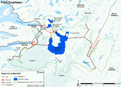 Map of Storglomvatnet watershed
 -
 Storglomvassdammen is one of the two big dams that create Storglomvatnet; the other one being Holmvassdammen.
 -
 The snow-covered dam in June 2015


See also
[edit | edit source]References
[edit | edit source]- ^ Lua error in Module:Citation/CS1/Configuration at line 2172: attempt to index field '?' (a nil value).
- ^ Lua error in Module:Citation/CS1/Configuration at line 2172: attempt to index field '?' (a nil value).
- ^ Lua error in Module:Citation/CS1/Configuration at line 2172: attempt to index field '?' (a nil value).
Lua error in Module:Authority_control at line 153: attempt to index field 'wikibase' (a nil value).
