Sayacmarca[1][2][3] is an archaeological site in Peru located in the Cusco Region, Urubamba Province, Machupicchu District. It is situated southwest of the archaeological site Runkuraqay and the Runkuraqay pass and southeast of the sites Phuyupatamarka and Qunchamarka.[4][5]
Hiram Bingham III visited the site in April 1915, referring to it as Cedrobamba, or cedar plain.[6]
- ^ Lua error in Module:Citation/CS1/Configuration at line 2172: attempt to index field '?' (a nil value).
- ^ Lua error in Module:Citation/CS1/Configuration at line 2172: attempt to index field '?' (a nil value).
- ^ Lua error in Module:Citation/CS1/Configuration at line 2172: attempt to index field '?' (a nil value).
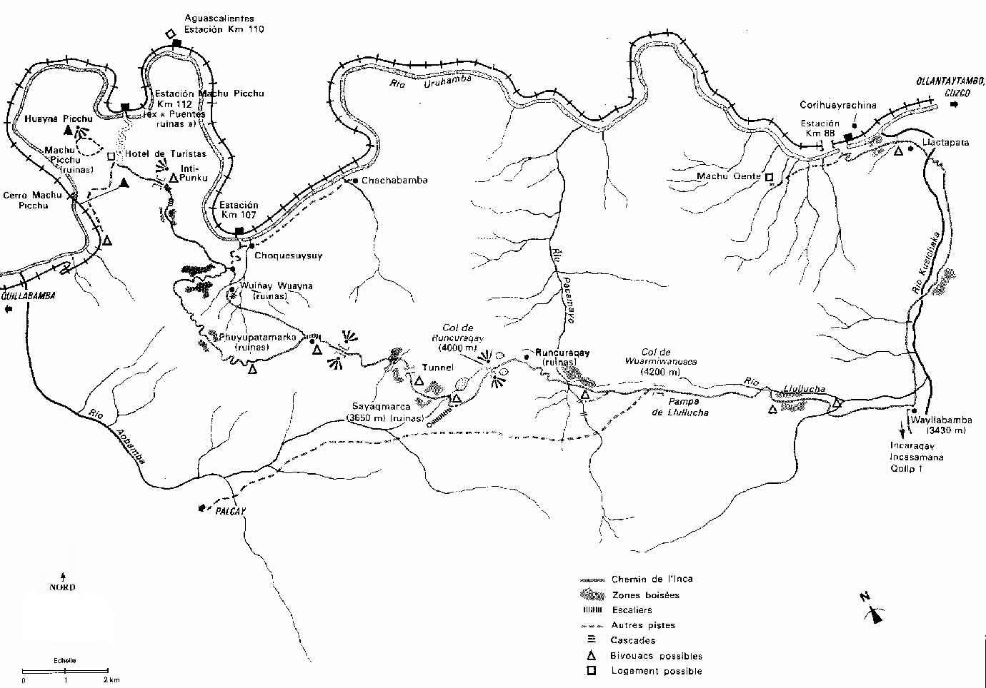
- ^ nroirand.free.fr Sketch map of the Inca trail
- ^ escale.minedu.gob.pe - UGEL map of the Urubamba Province (Cusco Region)
- ^ Lua error in Module:Citation/CS1/Configuration at line 2172: attempt to index field '?' (a nil value).
File:Wayllabamba Puesto de Vigilancia sign.jpgLocation of Sayacmarca as shown on a sign near Willkaraqay
Lua error in Module:Coordinates at line 489: attempt to index field 'wikibase' (a nil value).
|
|---|
- Acaray
- Ahuila Gencha Machay
- Amaru Marka Wasi
- Arhuaturo
- Asana
- Asiru Phat'jata
- Aspero
- Auga Punta
- Auquilohuagra
- Awkin Punta
- Awkimarka (Apurímac)
- Awkimarka (Huánuco)
- Aya Muqu
- Ayamachay
- Ayawayq'u
- Azángaro
- Baths of Boza
- Bandurria
- Buena Vista
- Cahuachi
- Cajamarquilla
- Cao Viejo
- Carachupa
- Carajía
- Caral
- Caves of Sumbay
- Cerro Baúl
- Cerro Pátapo
- Cerro Trinidad
- Chacamarca
- Chan Chan
- Chanquillo
- Chauchilla Cemetery
- Chavín de Huantar
- Chawaytiri
- Cheqollo
- Chichakuri
- Chipaw Marka
- Choquepuquio
- Choquequirao
- Choquequirao Puquio
- Churajón
- Chuya
- Cochabamba
- Cochapata
- Colcampata
- Collor
- Condorcaga
- Cota Coca
- Coricancha
- Cumbemayo
- Cutimbo
- El Brujo
- El Cañoncillo
- El Ingenio
- El Paraíso
- Garagay
- Gran Pajatén
- Gran Vilaya
- Guellayhuasin
- Guitarrero Cave
- Hatun Machay
- Hatun Misapata
- Hatun Rumiyoc
- Hatun Uchku
- Hatun Usnu
- Hatunmarka
- Honcopampa
- Huaca de la Luna
- Huaca del Dragón
- Huaca del Sol
- Huaca Huallamarca
- Huaca Prieta
- Huaca Pucllana
- Huaca San Marcos
- Huaca Santa Ana
- Huacramarca
- Hualpayunca
- Huamanmarca, La Convención
- Huamboy
- Huankarán
- Huaycán de Pariachi
- Huánuco Pampa
- Huari
- Huayna Picchu
- Huayrapongo
- Huchuy Qosqo
- Huiñao
- Inca Uyo
- Incahuasi, Lima
- Ingatambo
- Inka Mach'ay
- Inka Raqay, Apurímac
- Inka Raqay, Ayacucho
- Inka Tampu, Huayopata
- Inka Tampu, Vilcabamba
- Inka Tunuwiri
- Inka Wasi, Ayacucho
- Inka Wasi, Huancavelica
- Inkapintay
- Inkilltambo
- Inti Punku
- Inti Watana, Ayacucho
- Inti Watana, Calca
- Inti Watana, Urubamba
- Intikancha
- Intini Uyu Pata
- Intipa Ñawin
- Intiyuq K'uchu
- Iskuqucha
- Isog
- Jinkiori
- Jisk'a Iru Muqu
- Kanamarka
- Kanichi
- Kenko
- Killa Mach'ay
- Killarumiyuq
- Kotosh
- Kuelap
- Kukuli
- Kuntur Wasi
- Kunturmarka, Ayacucho
- Kunturmarka, Pasco
- Kuntuyuq
- Kusichaka valley
- Khichuqaqa
- Khuchi Mach'ay
- K'allapayuq Urqu
- K'ipakhara
- La Otra Banda
- Laguna de las Momias
- Lauricocha Caves
- Layzón
- Llactan
- Llamachayuq
- Llamachayuq Qaqa
- Llamayuq
- Llamuqa
- Llaqta Qulluy, Acoria
- Llaqta Qulluy, Conayca
- Llaqta Qulluy, Tayacaja
- Llaqta Qulluy, Vilca
- Llaqtapata
- Machu Colca
- Machu Picchu
- Machu Pirqa
- Machu Pitumarka
- Machu Q'inti
- Mallkuamaya
- Mameria
- Maray Qalla
- Marayniyoq
- Marcahuamachuco
- Markahirka
- Markansaya
- Markapukyu
- Marpa
- Mawk'allaqta, Castilla
- Mawk'allaqta, Espinar
- Mawk'allaqta, La Unión
- Mawk'allaqta, Melgar
- Mawk'allaqta, Paruro
- Mawk'allaqta, Sandia
- Mawk'ataray
- Mazur
- Miculla
- Millka
- Miraflores
- Mirq'imarka
- Miyu Pampa
- Molloko
- Moray
- Mulinuyuq
- Mullu Q'awa
- Muyu Muyu
- Muyu Urqu
- Muyuq Marka
- Nazca Lines
- Nina Kiru
- Ninamarca
- Ñawpallaqta, Huanca Sancos
- Ñawpallaqta, Fajardo
- Ñawpallaqta, Lucanas
- Ñusta Hispana
- Ollantaytambo
- Pacatnamu
- Pachacamac
- Pachatusan
- Paiján
- Pañamarca
- Paracas Candelabra
- Paraccra
- Patallaqta
- Pikillaqta
- Pikimach'ay
- Pilluchu
- Pinkuylluna
- Pirca Pirca, La Libertad
- Pirca Pirca, Lima
- Pirhuaylla
- Piruro
- Pirwayuq
- Písac
- Puka Pukara
- Puka Tampu
- Puka Urqu
- Pukara, Coporaque
- Pukara, Fajardo
- Pukara, Puno
- Pukara, Vilcas Huamán
- Pukarani
- Pumamarka, San Sebastián
- Pumamarka, Urubamba
- Pumaq Hirka
- Pumawasi
- Punkuri
- Puqin Kancha
- Puruchuco
- Purunllacta, Cheto
- Purunllacta, Soloco
- Pusharo
- Pusuquy Pata
- Puyupatamarca
- Qaqapatan
- Qenko
- Qillqatani
- Qillqa
- Qillqay Mach'ay
- Quiaca
- Quillarumi
- Quishuar
- Qullqapampa
- Qulu Qulu
- Qunchamarka
- Qunchupata
- Quri Winchus
- Qurimarka, Apurímac
- Qurimarka, Cusco
- Quriwayrachina, Anta
- Quriwayrachina, Ayacucho
- Quriwayrachina, La Convención
- Qasa Pata
- Qhapaq Kancha
- Raqch'i
- Revash
- Rumicolca
- Rumiwasi
- Runayoc
- Runkuraqay
- Sacsayhuamán
- Sara Sara
- Sayacmarca
- Sayhuite
- Sechín
- Sillustani
- Sipán
- Sóndor
- Soro Mik'aya Patjxa
- Susupillu
- Tambo Totem
- Tambomachay
- Tampu Mach'ay, Huancavelica
- Tampukancha
- Tanqa Tanqa
- Tantarica
- Taqrachullu
- Tarahuasi
- Tarmatambo
- Templo del Zorro
- The Toads of Wiraqucha
- Tikra
- Tinyaq
- Tipón
- Titiqaqa
- Toquepala Caves
- Toro Muerto
- Trinchera
- Túcume
- Tunanmarca
- Tunay Q'asa
- Tupu Inka
- T'akaq
- T'uqu T'uquyuq
- Uchkus Inkañan
- Urpish
- Uskallaqta
- Usnu, Ayacucho
- Usnu, Huánuco
- Usnu Muqu
- Usqunta
- Uyu Uyu
- Venado cautivo
- Ventanillas de Otuzco
- Ventarron
- Vilcabamba
- Vilcashuamán
- Viracochapampa
- Vitcos
- Waman Pirqa
- Wamanilla
- Wamanmarka, Chumbivilcas
- Wamanmarka, Lima
- Wanakawri, Cusco
- Wanakawri, Huánuco
- Waqlamarka
- Waqra Pukara
- Waqutu
- Warahirka
- Waraqayuq
- Waraqu Urqu
- Warawtampu
- Wari Willka
- Waruq
- Wat'a, Cusco
- Wat'a, Huánuco
- Wayna Q'inti
- Wayna Tawqaray
- Wichama
- Wichqana
- Wich'un
- Wila Wilani
- Wilca
- Wilcahuaín
- Willkaraqay
- Wiñay Wayna
- Wiraqucha Pirqa
- Yanaca
- Yanaqi - Qillqamarka
- Yaynu
- Yuraq Mach'ay
|