Rubene Parish
Jump to navigation
Jump to search
Rubene Parish | |
|---|---|
[[{{#property:P31}}]] | |
| {{#property:P18}} | |
|
{{#property:p41}} Flag {{#property:p158}} Seal {{#property:p94}} Coat of arms | |
| Nickname: {{#property:p1449}} | |
| {{#property:p242}} Lua error in Module:Coordinates at line 611: attempt to index field 'wikibase' (a nil value).Lua error in Module:EditAtWikidata at line 29: attempt to index field 'wikibase' (a nil value). | |
| Country | [[{{#property:P17}}]] |
| Area code | {{#property:P473}} |
| Website | {{ |
Rubene Parish (Latvian: Rubenes pagasts) is an administrative territorial entity of Jēkabpils Municipality, in the Selonia region of Latvia. It was an administrative unit of the Jēkabpils district. The administrative center is Rubeņi.
Towns, villages and settlements of Rubene Parish
[edit | edit source]- Kaldabruņa
- Rubeņi
- Slate
Gallery
[edit | edit source]-
 Lutheran church
 -
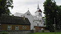 Catholic church
 -
 Rubene schoolhouse
 -
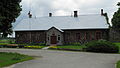 Local government building
 -
 House of culture
 -
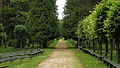 Park
Park -
 Singing square


External links
[edit | edit source]
Wikimedia Commons has media related to Rubene parish.
| Towns | |
|---|---|
| Parishes | |
Lua error in Module:Authority_control at line 153: attempt to index field 'wikibase' (a nil value). Lua error in Module:Coordinates at line 489: attempt to index field 'wikibase' (a nil value).
This Latvian location article is a stub. You can help Wikipedia by expanding it. |