Rolde
Jump to navigation
Jump to search
Rolde | |
|---|---|
 Jacobuskerk in 2009 | |
 Flag  Coat of arms | |
| Lua error in Module:Location_map at line 411: Malformed coordinates value. | |
| Coordinates: Lua error in Module:Coordinates at line 489: attempt to index field 'wikibase' (a nil value). | |
| Country | Netherlands |
| Province | Drenthe |
| Municipality | Aa en Hunze |
| Area | |
• Total | 24.67 km2 (9.53 sq mi) |
| Elevation | 16 m (52 ft) |
| Population (2021)[1] | |
• Total | 3,905 |
| • Density | 158.3/km2 (410.0/sq mi) |
| Time zone | UTC+1 (CET) |
| • Summer (DST) | UTC+2 (CEST) |
| Postal code | 9448 & 9451[1] |
| Dialing code | 0592 |
Rolde (Dutch pronunciation: [ˈrɔldə] <phonos file="Nl-rolde.ogg"></phonos>) is a village in the Dutch province of Drenthe. Located in the municipality of Aa en Hunze, it lies about 6 km (3.7 mi) east of Assen. In 2021, Rolde had a population of 3,905.[1]
History
[edit | edit source]Rolde was a separate municipality until 1998, when it became a part of the newly established municipality of Aa en Hunze.[3]
Although facilities are limited, Rolde possesses a ten-pin bowling alley. There are also two hunebeds on a site east of the church. The windmill has been restored to working order.
Gallery
[edit | edit source]-
 Former Rolde Town Hall
 -
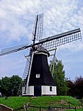 Rolde Windmill
 -
 Former town hall
 -
 Villa in Rolde


References
[edit | edit source]- ^ a b c d Lua error in Module:Citation/CS1/Configuration at line 2172: attempt to index field '?' (a nil value).
- ^ Lua error in Module:Citation/CS1/Configuration at line 2172: attempt to index field '?' (a nil value).
- ^ Ad van der Meer and Onno Boonstra, Repertorium van Nederlandse gemeenten, KNAW, 2011.
External links
[edit | edit source]- Error creating thumbnail: File missing Media related to Lua error in Module:Commons_link at line 62: attempt to index field 'wikibase' (a nil value). at Wikimedia Commons
Lua error in Module:Authority_control at line 153: attempt to index field 'wikibase' (a nil value).