MyWiki:Graphics Lab/Map workshop/Archive/Aug 2025
{{Wikipedia:Graphics Lab/Map workshop/Archive/2023}}
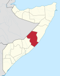
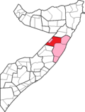
Location map of Somalia's administrative divisions and federal members
[edit source]-
 OCHA map of the member states, regions, and districts, 2023
 -
 Version of the current location map
 -
 Version of the current district maps


- Article(s)
- Administrative divisions of Somalia, States and regions of Somalia
- Request
- Could someone make a new location map with Somalia's regions, districts, and states based on the UN map above? The state boundaries do cross the other boundaries, as seen by the third image in relation to the first, so maybe it'll be better to have federal member state boundaries as a separate map from the others. I can make the highlighted maps; I just need a base map(s). Note that since the creation of the first image, a new member state has been added, which, according to a The Economist map, claims the same area as that Somaliland-Puntland disputed area. -- Wowzers122 (talk) 04:55, 30 July 2025 (UTC)
- Discussion
- @Wowzers122: are you after the SVG version of the first map? M.Bitton (talk) 12:32, 30 July 2025 (UTC)
- @M.Bitton: Yes. Wowzers122 (talk) 15:02, 30 July 2025 (UTC)
- @Wowzers122: all of it or just the base map (without the text)? M.Bitton (talk) 15:05, 30 July 2025 (UTC)
- @M.Bitton: Base like other location maps. Wowzers122 (talk) 15:10, 30 July 2025 (UTC)
- @Wowzers122: all of it or just the base map (without the text)? M.Bitton (talk) 15:05, 30 July 2025 (UTC)
- @M.Bitton: Yes. Wowzers122 (talk) 15:02, 30 July 2025 (UTC)
 Request taken by M.Bitton (talk) 13:23, 3 August 2025 (UTC).
Map of the Kingdom of Jerusalem
[edit source]- Request
We have plenty of maps of the kingdom and the other crusader states (here, here, here). Yet none of them... look right. What I would be most grateful for is a simple map showing important towns, castles, and bishoprics. This may or may not include borders of the kingdom; if it does, I would ask for a version with post-1153 borders and a version without borders. A good source would be Malcolm Barber's 2012 book The Crusader States, more precisely this map within it. Such a map would be useful in dozens of articles. Surtsicna (talk) 22:04, 30 June 2025 (UTC)
- Discussion
- It would have been great if you used the "New request" link at the top as it gives a structure to the requests which is easier for every one.
- I can help you with this but remember I have zero knowledge of the topic so you have to be clear on what you want, thanks.
- What I understand you basically want is a "copy" of the linked map, but I can only use it as information source and not directly copy it. --always ping me-- Goran tek-en (talk) 17:17, 19 August 2025 (UTC)
- I understand that it cannot be directly copied, @Goran tek-en. I would be fine with the addition of, say, rivers or even a full relief map or whatever is needed to make it different. Perhaps this map by Steven Runciman (A History of the Crusades) would also help to make something different. It is very difficult to find maps with borders in reliable sources because borders in the Middle Ages were very fluid, but Runciman's dashed lines might be helpful. Please note that there is a border between Jebeil (County of Tripoli) and Beirut (Kingdom of Jerusalem). Perhaps this inconstancy of borders could be denoted with a fading or smudged color? I don't know. So to be clear:
- A very simple map with the towns, castles, and bishoprics would be a priority.
- An attempt to portray the borders as they were in 1165 (Runciman's map) would be nice to see if you can bother to give it a try, but do not make them too clear-cut.
- Thanks for picking this up and I am looking forward to seeing your creative input. Surtsicna (talk) 18:51, 19 August 2025 (UTC)
![]() Request taken by --always ping me-- Goran tek-en (talk) 17:17, 19 August 2025 (UTC).
Request taken by --always ping me-- Goran tek-en (talk) 17:17, 19 August 2025 (UTC).
- @Surtsicna Would it be possible for you to provide me with links for the two maps which isn't imgur but a more lasting link. I always want to declare the sources even for information.
- I will be back with a draft and we can work from there, thanks for your knowledge. --always ping me-- Goran tek-en (talk) 11:09, 20 August 2025 (UTC)
- If you mean citations, @Goran tek-en, here they are:
- Lua error in Module:Citation/CS1/Configuration at line 2172: attempt to index field '?' (a nil value).
- Lua error in Module:Citation/CS1/Configuration at line 2172: attempt to index field '?' (a nil value).
- I can give you the page numbers tonight. Surtsicna (talk) 11:22, 20 August 2025 (UTC)
- @Surtsicna
- Thanks, is there a specific color which is associated with that Kingdom? --always ping me-- Goran tek-en (talk) 09:47, 22 August 2025 (UTC)
- Not in this time period, but we could go with gold, which is attested in the 13th century. Surtsicna (talk) 13:34, 22 August 2025 (UTC)
- @Surtsicna
- Everything is up for change in those drafts.
- You asked for "important towns, castles, and bishoprics", you have to tell me missed towns, castles, and bishoprics you have to tell me where (coordinates if possible) and I will add symbols and names.
- Ones everything is set we can do versions, with or without borders and other.
- ----
- Those drafts are PNG versions of the original SVG file I'm working in and will upload to commons.
- Those drafts are shown for proofreading only.
- ----
- --always ping me-- Goran tek-en (talk) 17:18, 22 August 2025 (UTC)
- Oh, you certainly made it look different, @Goran tek-en! I think the rivers and the relief help a lot. I have a few notes:
- The kingdom is not usually considered to have encompassed the land north of Beirut. In Runciman's map you will notice a dashed land north of Beirut denoting a border between the kingdom and the County of Tripoli.
- I like the first draft (without the line) better and I would even propose smudging the border a bit more in the southern area where it was really porous.
- The missing (and important) towns are Shaizar (close to Homs), al-Arish (to the south), the Monastery of St Sabas (near Bethlehem), Lydda (near Ramla), Sebaste (near Nablus), Arsuf (north of Jaffa), Mount Tabor (near Tiberias), Baisan (south of Tiberias), Toron and Banias (east of Tyre), Bosra (far south of Damascus), Montreal (south of Kerak).
- It might be useful to mark the monasteries, bishoprics, archbishoprics, and patriarchate as they are in Barber's map–just so that a major city like Acre or Tyre is not on the same footing as a single monastery.
- Daron should be Darum.
- The relative positions of Darum, Gaza, and Ascalon do not match those in Barber or those in Runciman (and they differ between Barber and Runciman). I do not know what to make of it. Surtsicna (talk) 22:16, 22 August 2025 (UTC)
- @Surtsicna
- Draft kingdom area 2
- Border north, on that map the border north-south is dashed all the way. There is a small line west-east just above Beirut, I can't see any dashed land.
- Is the black line below Beirut correct?
- If this is correct we can cut away quite a bit up north, red line?
- South, softer? If so tell me south-west south-east...
- Shaizar, on todays map it's south of the river but the old is north of river, which?
- If there are any major cities you want to be marked out, list them.
- I have adjust the cities which differ between the maps to something in between. It is extremely difficult to compare a position between different maps and specially old ones compared to today's.
- Montreal is also much more south on Barber's map, move it?
- --always ping me-- Goran tek-en (talk) 17:40, 23 August 2025 (UTC)
- @Goran tek-en,
- The border between the Kingdom of Jerusalem and the County of Tripoli as visible in Runciman's map is the solid black line starting at the coast between Jebeil and Beirut (it might be solid because it is too short to be dashed).
- The border in the draft map appears south of Beirut, but it should be just to the north, as Beirut belonged to the kingdom. I would also suggest restricting the golden color denoting the kingdom to the area up to Beirut, i.e. not north of it, as that's where the County of Tripoli was.
- I would not cut away at the north. It's important to show the neighbors for context.
- I think it is now soft enough in the south-west and could be a tad bit softer in the south-east.
- Old Shaizar (the fortress) was north of the Orontes. Let's put it there.
- Montreal's coordinates are 30°31′52.84″N 35°33′40.47″E.
- Might it be possibly to depict the internal division of the kingdom based on this map found in Jonathan Riley-Smith's The Feudal Nobility and the Kingdom of Jerusalem (1974)? It is fairly close to what we have in File:1889 The Kingdom of Jerusalem, shewing the Fiefs, about 1187 A.D..jpg. I would not know how to depict this internal division. Any kind of lines, even dashed like in Riley-Smith's map, would probably not match well with the smudged kingdom borders we have now.
- Surtsicna (talk) 10:03, 24 August 2025 (UTC)
- @Surtsicna
- Shaizar, I have put it where your link shows it, if this is not correct you have to give me another location.
- Before I see what I can do with the internal lines we have to decide which to use. In this draft the red lines are what I could see in the map we have at commons. The green lines are what I could see looking at the map by Jonathan Riley-Smith's.
- Using the grid you should be able to tell me which to use, thanks.
- Draft internal
- --always ping me-- Goran tek-en (talk) 14:50, 24 August 2025 (UTC)
- I do not see the version with Shaizar anymore, but I think you had it right (on the Orontes, to the north). Let's go with Riley-Smith; it's newer scholarship. Thanks, @Goran tek-en! Surtsicna (talk) 15:52, 24 August 2025 (UTC)
- @Surtsicna
- Some of the borders up north is outside of the kingdom, remove or what?
- This is one example of borders, there are many ways to do them
- Draft kingdom 3
- --always ping me-- Goran tek-en (talk) 16:50, 25 August 2025 (UTC)
- Please move the border just a little bit north so that Beirut is not sitting right on the border. The border should be closer to Jebeil (Runciman's map). I now see that the southern part of the kingdom looks a bit off without any internal borders, which may or may not be correct... I think it would be best to have a map without the internal borders and then another map with the internal borders but not showing the Negev. Surtsicna (talk) 20:55, 26 August 2025 (UTC)
- @Surtsicna
- Please always ping me or I wont get a notification all the time, thanks.
- We can do two different maps but I don't understand "but not showing the Negev" as we don't show it at all.
- Draft kingdom 4
- --always ping me-- Goran tek-en (talk) 10:36, 30 August 2025 (UTC)
- @Goran tek-en Always ping, got it :) I meant the southern triangular part, the one that we don't see in Riley-Smith's map. Surtsicna (talk) 08:02, 31 August 2025 (UTC)
- @Surtsicna
- For the version without borders, do you want the overall map covering the same area or should I cut of in the south? --always ping me-- Goran tek-en (talk) 12:44, 31 August 2025 (UTC)
- @Surtsicna
- I haven't heard from you so I show you the two variations;
- --always ping me-- Goran tek-en (talk) 14:58, 4 September 2025 (UTC)
- Oh, sorry. I somehow missed this notification! "Draft kingdom borders" looks very good. I think our best option would be to have that map without the internal borders (so including the southern tip but not the internal borders). I must admit that I cannot quite tell what those internal borders are supposed to represent, so they pose more questions than answers. And with that I can stop nagging you :D Surtsicna (talk) 15:06, 4 September 2025 (UTC)
- @Surtsicna
- No problem, I just have to understand what you mean, it's not always so easy to communicate.
- If this last draft is fine then I will need the following for the two versions;
- Name of the file
- Description (/language)
- Captions/s (/language)
- Category/ies at commons
- Structured data/Items portrayed in this file, the Q#, to be able to upload it at commons, thanks.
- --always ping me-- Goran tek-en (talk) 12:43, 5 September 2025 (UTC)
- @Goran tek-en I missed this ping! Let's say:
- Name of the file: Principal locations in the Kingdom of Jerusalem
- Description: Cities, towns, bishoprics, and monasteries in the Kingdom of Jerusalem
- Caption: can be the same as description
- Category: Maps of the Kingdom of Jerusalem
- Structured data: honestly, no clue; I have never filled that out when uploading files
- I am really looking forward to this! Surtsicna (talk) 00:20, 11 September 2025 (UTC)
- @Goran tek-en I missed this ping! Let's say:
- Oh, sorry. I somehow missed this notification! "Draft kingdom borders" looks very good. I think our best option would be to have that map without the internal borders (so including the southern tip but not the internal borders). I must admit that I cannot quite tell what those internal borders are supposed to represent, so they pose more questions than answers. And with that I can stop nagging you :D Surtsicna (talk) 15:06, 4 September 2025 (UTC)
- @Goran tek-en Always ping, got it :) I meant the southern triangular part, the one that we don't see in Riley-Smith's map. Surtsicna (talk) 08:02, 31 August 2025 (UTC)
- Please move the border just a little bit north so that Beirut is not sitting right on the border. The border should be closer to Jebeil (Runciman's map). I now see that the southern part of the kingdom looks a bit off without any internal borders, which may or may not be correct... I think it would be best to have a map without the internal borders and then another map with the internal borders but not showing the Negev. Surtsicna (talk) 20:55, 26 August 2025 (UTC)
- @Surtsicna
- I do not see the version with Shaizar anymore, but I think you had it right (on the Orontes, to the north). Let's go with Riley-Smith; it's newer scholarship. Thanks, @Goran tek-en! Surtsicna (talk) 15:52, 24 August 2025 (UTC)
- @Surtsicna
- @Goran tek-en,
- Oh, you certainly made it look different, @Goran tek-en! I think the rivers and the relief help a lot. I have a few notes:
- @Surtsicna
- Not in this time period, but we could go with gold, which is attested in the 13th century. Surtsicna (talk) 13:34, 22 August 2025 (UTC)
- If you mean citations, @Goran tek-en, here they are:
Surtsicna Now you can find them here
- Commons:file:Principal locations in the Kingdom of Jerusalem.svg
- Commons:file:Principal locations in the Kingdom of Jerusalem internal borders.svg
- Please check all the information, also links for wikipedia, wikidata and structured data.
- If you are happy with this please put the code
{{re.solved|~~~~}}(without the ".") on this request so it can be archived, thanks.
![]() Done --always ping me-- Goran tek-en (talk) 13:23, 11 September 2025 (UTC)
Done --always ping me-- Goran tek-en (talk) 13:23, 11 September 2025 (UTC)
2025 Tour de France Femmes
[edit source]{{stale}}
- Article(s)
- 2025 Tour de France Femmes
- Request
- Hi, I'm looking for someone to do a free version of the 2025 Tour de France Femmes map - the official one is here. As previously, I asked Andrei loas who has previously done excellent maps (e.g. this for the 2015 men's race) if he could create one, but he hasn't got back to me unfortunately.
- Three examples - excellent maps from previous years by M.Bitton and Groetjes, Peter.

- The Tour de France Femmes is now Wikipedia:ITN/R, so I hope that a map can neatly illustrate the article. Thanks in advance! Turini2 (talk) 10:30, 11 July 2025 (UTC)
 Done @Turini2: Maybe too late. Tell me what I got wrong! Lars A (talk) 04:07, 29 August 2025 (UTC)
-
 Tour de France Femmes 2025

- Discussion
- I'll take a look at it tomorrow. Groetjes, Peter (talk) 11:06, 11 July 2025 (UTC)
- Hey, just to politely remind you about this - thanks! Turini2 (talk) 10:02, 22 July 2025 (UTC)
- @Groetjes, Peter hey? just to chase you about this, given this will likely be on the front page after this weekend. Thanks! Turini2 (talk) 20:04, 31 July 2025 (UTC)
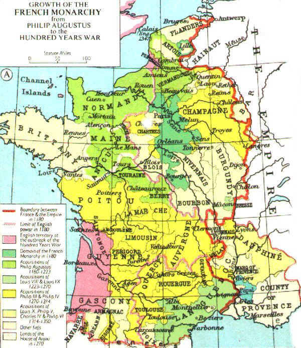
Small amendment to SVG map of France in 1328
[edit source]-
 Map of France in 1328
 -
 Map of France in 1328


- Article(s)
- English claims to the French throne, Hundred Years' War + 10 other wp.en articles
- Request
- The map shows English territory in pink in France in 1328. However, it omits Ponthieu which is a small enclave in north east France on the coast of the English Channel. Source: see map here - Lua error in Module:Citation/CS1/Configuration at line 2172: attempt to index field '?' (a nil value).
- I believe this is the page of Muir's Historical Atlas which was the original source.
- Could the Ponthieu enclave be coloured pink per the source please? DeCausa (talk) 10:11, 24 August 2025 (UTC)
- Request taken by Lars A (talk) 12:39, 29 August 2025 (UTC).
- Done I used the Spanish-language map as a base instead.
- https://commons.wikimedia.org/wiki/File:Guyenne_1328-es.svg
- If you prefer I can use the one you supplied. Lars A (talk) 10:46, 30 August 2025 (UTC)
- That's great. Thanks very much. DeCausa (talk) 14:06, 30 August 2025 (UTC)
- @Lars A: I just noticed something. I agree that the Spanish-language map base is an improvement. However, it shows the Channel Islands which the original map didn't - they were missing. That's fine except that if we show the Channel islands they should aslo be pink (they're purple currently). Would it be possible to make that change? DeCausa (talk) 00:05, 31 August 2025 (UTC)
- That's great. Thanks very much. DeCausa (talk) 14:06, 30 August 2025 (UTC)
- Discussion
Yangtze River Economic Belt
[edit source]-
 Provinces of YREB

I am writing Draft:Yangtze River Economic Belt and I would like a map showing where it is. I believe it should include Yunnan, Guizhou, Sichuan, Chongqing, Hubei, Jiangxi, Jiangsu, Zhejiang, and Shanghai. Could any of you please make that map? Thanks, ✶Quxyz✶ (talk) 17:24, 25 August 2025 (UTC)
Simple location map: Boghead (bastle)
[edit source]Could someone help me with a simple pushpin map to show the location of Boghead in Northumberland (or perhaps Britain)? The site is located at OSGB NY 76124 91005, but I don't know how to make that work with {{location}}. Thanks! Josh Milburn (talk) 06:33, 21 September 2025 (UTC)
- @J Milburn: According to http://gridreferencefinder.com/#gr=NY7612491005%7CNY_s_76124_s_91005%7C1, NY 76124 91005 is 55°12′46″N, 2°22′36″W or 55.212704, -2.3767659. The correct template is Template:location map. Feel free to tweak the map above. cmɢʟee τaʟκ (please add
{{ping|cmglee}}to your reply) 11:10, 28 September 2025 (UTC)
Location map of Ardatov District
[edit source]-
 Location map of Nizhny Novgorod Oblast
 -
 Location map of Ardatovsky District
.svg)
.svg)
- Article(s)
- List of populated places in Ardatov District, Nizhny Novgorod Oblast
- Request
Hi, I'm an administrator of Russian Wikipedia, and I wrote the List of inhabited places of Ardatov District, Nizhny Novgorod Oblast, Russia for English Wikipedia too. As you may see, there is a location map in the article, which a colleague from the Russian Wikipedia cut from the location map of Nizhny Novgorod Oblast. But it does not work properly (both in English and Russian sections), as the location of the populated places on it do not stay on the correct places. I would appreciate if somebody could create a correct location map from the existing file, or a new file linked to the correct geo coordinates. If needed, here is a link of the District's map on Open Street Maps. I need only a yellow map with no details in it. Thank you in advance. 𝓛𝓮𝓸𝗞 𝗮 𝗻 𝗱 (talk) 11:25, 22 September 2025 (UTC)
- Discussion
@Leokand: Am I mistaken in assuming that this oblast is also known as Nizhegorod? M.Bitton (talk) 16:03, 28 September 2025 (UTC)
- It's a very strange word, I've never seen it before. In Russian in is called Nizhegorodskaya Oblast (Нижегородская область) which is the adjective from it's main city's name Nizhny Novgorod (Нижний Новгород). The form Nizhegorod is neither a Russian, nor an English word. 𝓛𝓮𝓸𝗞 𝗮 𝗻 𝗱 (talk) 01:34, 29 September 2025 (UTC)
- @Leokand: I used the data that I already had (with a bit of apprehension, given what you said above). Please try it and let me know what you think. M.Bitton (talk) 00:32, 2 October 2025 (UTC)
- Sorry, maybe I did not express well enough, but I need the location map of Ardatov District only, not of the whole Nizhny Novgorod oblast. 𝓛𝓮𝓸𝗞 𝗮 𝗻 𝗱 (talk) 08:53, 2 October 2025 (UTC)
- You explained it well, but for some reason, I kept thinking of Nizhegorod. Anyway, it's all done now (assuming that "Ardatov District" and "Ardatovsky District" refer to the same thing). M.Bitton (talk) 16:38, 2 October 2025 (UTC)
- Done. Thank you very much, now it's perfect. 𝓛𝓮𝓸𝗞 𝗮 𝗻 𝗱 (talk) 10:36, 3 October 2025 (UTC)
- You explained it well, but for some reason, I kept thinking of Nizhegorod. Anyway, it's all done now (assuming that "Ardatov District" and "Ardatovsky District" refer to the same thing). M.Bitton (talk) 16:38, 2 October 2025 (UTC)
- Sorry, maybe I did not express well enough, but I need the location map of Ardatov District only, not of the whole Nizhny Novgorod oblast. 𝓛𝓮𝓸𝗞 𝗮 𝗻 𝗱 (talk) 08:53, 2 October 2025 (UTC)
- @Leokand: I used the data that I already had (with a bit of apprehension, given what you said above). Please try it and let me know what you think. M.Bitton (talk) 00:32, 2 October 2025 (UTC)