Mount Wolverine
| Mount Wolverine | |
|---|---|
| File:Mount Wolverine.jpg North aspect, summit on the left | |
| Highest point | |
| Elevation | 10,795 ft (3,290 m)[1][2] |
| Prominence | 575 ft (175 m)[3] |
| Parent peak | Sugarloaf Mountain[3] |
| Isolation | 1.76 mi (2.83 km)[3] |
| Coordinates | Lua error in Module:Coordinates at line 489: attempt to index field 'wikibase' (a nil value).[4] |
| Naming | |
| Etymology | Wolverine |
| Geography | |
Lua error in Module:Location_map at line 411: Malformed coordinates value.
| |
| Country | United States |
| State | Utah |
| County | Salt Lake |
| Parent range | Wasatch Range[5] Rocky Mountains |
| Topo map | USGS Brighton |
| Geology | |
| Rock age | 33 Ma |
| Rock type | Granodiorite[6] (Igneous rock)[1] |
| Climbing | |
| Easiest route | class 2+ scrambling[3] |
Mount Wolverine is a 10,795-foot-elevation (3,290-meter) summit in Salt Lake County, Utah, United States.
Description
[edit | edit source]Mount Wolverine is located 20 miles (32 km) southeast of downtown Salt Lake City between the Alta Ski Area and the Brighton Ski Resort in the Wasatch–Cache National Forest.[5] The peak is set in the Wasatch Range which is a subset of the Rocky Mountains. Precipitation runoff from the mountain's north slope drains into headwaters of Big Cottonwood Creek, whereas the south slope drains into headwaters of Little Cottonwood Creek. Topographic relief is significant as the summit rises 1,800 feet (549 meters) above Little Cottonwood Canyon in approximately one mile (1.6 km). Mount Wolverine is composed of granodiorite of the igneous Alta stock.[7] This mountain's toponym has been officially adopted by the United States Board on Geographic Names.[4]
Climate
[edit | edit source]Mount Wolverine has a subarctic climate (Köppen Dfc), bordering on an Alpine climate (Köppen ET), with long, cold, snowy winters, and cool to warm summers.[8] Due to its altitude, it receives precipitation all year, as snow in winter, and as thunderstorms in summer.
Gallery
[edit | edit source]-
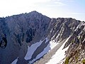 Northwest face above the cirque
 -
Southwest aspect viewed from Sugarloaf Mountain. Albion Basin below.
-
View from Sunset Peak with Mount Wolverine (upper left), Mount Tuscarora (center), and Mount Millicent (right).


References
[edit | edit source]- ^ a b William T. Parry, Geology of Utah's Mountains, Peaks, and Plateaus, 2016, FriesenPress, Lua error in Module:Citation/CS1/Configuration at line 2172: attempt to index field '?' (a nil value)..
- ^ Jared Hargrave, Backcountry Ski & Snowboard Routes: Utah, Mountaineers Books, 2015, Lua error in Module:Citation/CS1/Configuration at line 2172: attempt to index field '?' (a nil value).
- ^ a b c d Lua error in Module:Citation/CS1/Configuration at line 2172: attempt to index field '?' (a nil value).
- ^ a b Lua error in Module:Citation/CS1/Configuration at line 2172: attempt to index field '?' (a nil value).
- ^ a b Lua error in Module:Citation/CS1/Configuration at line 2172: attempt to index field '?' (a nil value).
- ^ The Salt Lake Region, J. Cecil Alter, U.S. Government Printing Office, 1932, p. 94.
- ^ Miriam H. Bugden, Geology and Scenery of the Central Wasatch Range, Salt Lake and Summit Counties, Utah, Utah Geological Survey, 1991, Lua error in Module:Citation/CS1/Configuration at line 2172: attempt to index field '?' (a nil value)., p. 12
- ^ Lua error in Module:Citation/CS1/Configuration at line 2172: attempt to index field '?' (a nil value).
External links
[edit | edit source]- Mount Wolverine: weather forecast


Lua error in mw.title.lua at line 392: bad argument #2 to 'title.new' (unrecognized namespace name 'Portal').