Mount Behistun
Jump to navigation
Jump to search
This article needs additional citations for verification. (February 2024) |
| Mount Behistun | |
|---|---|
| File:نمایی از بیستون وسراب بیستون - panoramio.jpg | |
| Highest point | |
| Coordinates | Lua error in Module:Coordinates at line 489: attempt to index field 'wikibase' (a nil value). |
| Naming | |
| Native name | بیستون (Persian) |
| Geography | |
Lua error in Module:Location_map at line 411: Malformed coordinates value.
| |
| Parent range | Zagros Mountains |
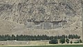
Mount Bisotoun (or Behistun and Bisotun) is a mountain of the Zagros Mountains range, located in Kermanshah Province, western Iran. It is located 525 kilometers (326 mi) west of Tehran.
Cultural history
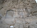
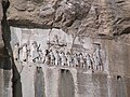
[edit | edit source]Mount Bisotoun, aka Bīsitūn (referring to the mountain and the nearby village), is a mountain with a rock precipice in the Zagros Mountains in Kermanshah, Iran. Darius I inscribed the flat rock face in three languages c. 500 BC, known as the Behistun Inscription.[1]
Legends
[edit | edit source]A legend began around Mount Bisotoun, as written about by the Persian poet Nezami about a man named Farhad, who was a lover of Shirin.
Gallery
[edit | edit source]-
 Farhad Tarash at the base of Mount Behistun
 -
 Farhad Tarash at the base of Mount Behistun
 -
 Goudarz
 -

-


References
[edit | edit source]- ^ Lua error in Module:Citation/CS1/Configuration at line 2172: attempt to index field '?' (a nil value).