Kuthar


Kuthar, formerly Krishangarh, is located in the Solan district of Himachal Pradesh. Krishangarh (Kuthar) is situated on the MDR-75 i.e. Shalaghat-Arki-Kunihar-Kuthar-Patta-Brotiwala (previously known as State Highway-9) adjoining Sabathu, Kasauli area. Krishangarh is an administrative division of Solan district having sub-tehsil status.
History
[edit | edit source]Kuthar was a princely state of the British Raj, located in modern-day Himachal Pradesh. It was one of the several states of the Punjab States Agency.
The state of Kuthar was founded in the 17th century. It was occupied by Nepali forces during drive of Himalayas from 1803 to 1815.
Rulers
[edit | edit source]The rulers bore the title of rana.[1][2]
- 1803 - Gopal Singh
- 1815 - 1858 Bhup Singh
- 1858 - 1896 Jai Chand
- 1896 - 1930 Jagjit Chand
- 1930 - 15 August 1947 Krishna Chand (born 1905)
Gallery
[edit | edit source]-
 A view of the palace
 -
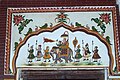 Wall painting, Kuthar palace
 -
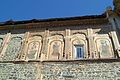 Architecture and art work of the palace of Kuthar
 -
 Art work on the entrance of the palace of Kuthar
 -
 Art work on the outer walls of the palace of Kuthar
 -
 Interior wall paintings on the palace of Kuthar
 -
 Interior art work on the roof of Kuthar palace


See also
[edit | edit source]- http://www.worldstatesmen.org/India_princes_K-W.html
- https://masalamug.com/kuthar-hideout-in-himachal/
References
[edit | edit source]Lua error in Module:Coordinates at line 489: attempt to index field 'wikibase' (a nil value).
This Indian history-related article is a stub. You can help Wikipedia by expanding it. |
This Himachal Pradesh location article is a stub. You can help Wikipedia by expanding it. |