Konzell
Jump to navigation
Jump to search
 | You can help expand this article with text translated from the corresponding article in Deutsch. (March 2009) Click [show] for important translation instructions.
|
Konzell | |
|---|---|
 Church of Saint Martin | |
 Coat of arms | |
Location of Konzell
within Straubing-Bogen district 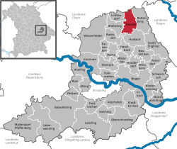 | |
| Lua error in Module:Infobox_mapframe at line 197: attempt to index field 'wikibase' (a nil value). | |
| Lua error in Module:Location_map at line 411: Malformed coordinates value. | |
| Coordinates: Lua error in Module:Coordinates at line 489: attempt to index field 'wikibase' (a nil value). | |
| Country | Germany |
| State | Bavaria |
| Admin. region | Niederbayern |
| District | Straubing-Bogen |
| Government | |
| • Mayor (2020–26) | Hans Kienberger[1] (CSU) |
| Area | |
• Total | 26.75 km2 (10.33 sq mi) |
| Highest elevation | 900 m (3,000 ft) |
| Lowest elevation | 500 m (1,600 ft) |
| Population (Lua error in Module:Settlement_Wikidata at line 197: attempt to index field 'wikibase' (a nil value).)Lua error in Module:Settlement_Wikidata at line 197: attempt to index field 'wikibase' (a nil value). | |
• Total | Lua error in Module:Settlement_Wikidata at line 197: attempt to index field 'wikibase' (a nil value). |
| Time zone | UTC+01:00 (CET) |
| • Summer (DST) | UTC+02:00 (CEST) |
| Postal codes | 94357 |
| Dialling codes | 09963 |
| Vehicle registration | SR |
| Website | www.konzell.de |
Konzell (German pronunciation: [ˈkɔntsɛl]) is a municipality in the district of Straubing-Bogen in Bavaria, Germany.
Geography
[edit | edit source]Konzell is situated in the south of the Bavarian Forest. Here is the spring of the Menach, which flows in the valley of Menach direction the Bogen.
Mountains
[edit | edit source]The Gallner Berg to the south, the western summit of the Gallner, and the Kramerschopf to the east are the highest points, each reaching 710 metres. To the north is the Himmelberg at 680 metres.
Urban districts
[edit | edit source]To Konzell belong the urban districts Auggenbach, Denkzell, Gossersdorf and Kasparzell.
Impressions
[edit | edit source]-
 Rectory
 -
 Primary school
 -
 fountain near school and church
 -
 Brewerie (Klett-Bräu)


References
[edit | edit source]Lua error in Module:Authority_control at line 153: attempt to index field 'wikibase' (a nil value).
 | This Straubing-Bogen location article is a stub. You can help Wikipedia by expanding it. |