Inchenhofen
Jump to navigation
Jump to search
Inchenhofen | |
|---|---|
|
Coat of arms of Inchenhofen Coat of arms | |
Location of Inchenhofen
within Aichach-Friedberg district 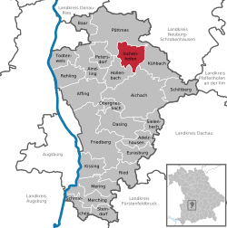 | |
| Lua error in Module:Infobox_mapframe at line 197: attempt to index field 'wikibase' (a nil value). | |
| Lua error in Module:Location_map at line 411: Malformed coordinates value. | |
| Coordinates: Lua error in Module:Coordinates at line 489: attempt to index field 'wikibase' (a nil value). | |
| Country | Germany |
| State | Bavaria |
| Admin. region | Schwaben |
| District | Aichach-Friedberg |
| Government | |
| • Mayor (2020–26) | Anton Schoder[1] |
| Area | |
• Total | 27.55 km2 (10.64 sq mi) |
| Highest elevation | 485 m (1,591 ft) |
| Lowest elevation | 460 m (1,510 ft) |
| Population (Lua error in Module:Settlement_Wikidata at line 197: attempt to index field 'wikibase' (a nil value).)Lua error in Module:Settlement_Wikidata at line 197: attempt to index field 'wikibase' (a nil value). | |
• Total | Lua error in Module:Settlement_Wikidata at line 197: attempt to index field 'wikibase' (a nil value). |
| Time zone | UTC+01:00 (CET) |
| • Summer (DST) | UTC+02:00 (CEST) |
| Postal codes | 86570 |
| Dialling codes | 08257 |
| Vehicle registration | AIC |
| Website | www.inchenhofen.de |
Inchenhofen (also known as Leahad in the local tongue) is a municipality in the district of Aichach-Friedberg in Bavaria in Germany.
Leahad refers to the fact, that it is a pilgrimage site for Saint Leonard of Noblac. Until the Secularisation, it was the most important pilgrimage site of this saint in central Europe.
References
[edit | edit source]
Lua error in Module:Authority_control at line 153: attempt to index field 'wikibase' (a nil value).