Howe Valley, Kentucky
Jump to navigation
Jump to search
Howevalley, Kentucky | |
|---|---|
| Lua error in Module:Location_map at line 411: Malformed coordinates value. | |
| Coordinates: Lua error in Module:Coordinates at line 489: attempt to index field 'wikibase' (a nil value). | |
| Country | United States |
| State | Kentucky |
| County | Hardin |
| Elevation | 682 ft (208 m) |
| Time zone | UTC-5 (Eastern (EST)) |
| • Summer (DST) | UTC-4 (EDT) |
| Area codes | 270 & 364 |
| GNIS feature ID | 494687[1] |
Howevalley is an unincorporated community in Hardin County, Kentucky, United States. Howe Valley is located on Kentucky Route 86 12.3 miles (19.8 km) west of Elizabethtown.[2]
A post office operated in the community from 1852 to 1908. Howevalley (also historically spelled Howe's Valley and Howevalley) is situated in a valley of the same name, which in turn was named for John Howe, an early settler.[3] John Howe was in the American Revolutionary War and was given the land for his work.
References
[edit | edit source]- ^ Lua error in Module:Citation/CS1/Configuration at line 2172: attempt to index field '?' (a nil value).
- ^ Lua error in Module:Citation/CS1/Configuration at line 2172: attempt to index field '?' (a nil value).
- ^ Lua error in Module:Citation/CS1/Configuration at line 2172: attempt to index field '?' (a nil value).
Municipalities and communities of Hardin County, Kentucky, United States | ||
|---|---|---|
| Cities | 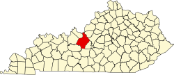 | |
| CDPs | ||
| Other unincorporated communities | ||
| Footnotes | ‡This populated place also has portions in an adjacent county or counties | |
Lua error in Module:Authority_control at line 153: attempt to index field 'wikibase' (a nil value).
This Hardin County, Kentucky state location article is a stub. You can help Wikipedia by expanding it. |