Hohnstein
Hohnstein | |
|---|---|
| General view of the town General view of the town | |
|
Coat of arms of Hohnstein Coat of arms | |
Location of Hohnstein
within Sächsische Schweiz-Osterzgebirge district 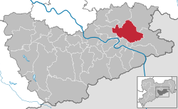 | |
| Lua error in Module:Infobox_mapframe at line 197: attempt to index field 'wikibase' (a nil value). | |
| Lua error in Module:Location_map at line 411: Malformed coordinates value. | |
| Coordinates: Lua error in Module:Coordinates at line 489: attempt to index field 'wikibase' (a nil value). | |
| Country | Germany |
| State | Saxony |
| District | Sächsische Schweiz-Osterzgebirge |
| Government | |
| • Mayor (2022–29) | Daniel Brade[1] |
| Area | |
• Total | 64.64 km2 (24.96 sq mi) |
| Elevation | 330 m (1,080 ft) |
| Population (Lua error in Module:Settlement_Wikidata at line 197: attempt to index field 'wikibase' (a nil value).)Lua error in Module:Settlement_Wikidata at line 197: attempt to index field 'wikibase' (a nil value). | |
• Total | Lua error in Module:Settlement_Wikidata at line 197: attempt to index field 'wikibase' (a nil value). |
| Time zone | UTC+01:00 (CET) |
| • Summer (DST) | UTC+02:00 (CEST) |
| Postal codes | 01848 |
| Dialling codes | 035975 |
| Vehicle registration | PIR |
| Website | www.hohnstein.de |
Hohnstein (German pronunciation: [ˈhoːnˌʃtaɪn] <phonos file="De-Hohnstein.ogg"></phonos>) is a town located in the Sächsische Schweiz-Osterzgebirge district of Saxony, in eastern Germany. As of 2020, its population numbered a total of 3,262.
Geography
[edit | edit source]It is situated in Saxon Switzerland, 12 km east of Pirna, and 28 km southeast of Dresden (centre). It is dominated by its castle, standing on a sandstone rock.
The municipal territory includes the villages (Ortsteile) of Cunnersdorf, Ehrenberg, Goßdorf, Lohsdorf, Rathewalde, Ulbersdorf and Waitzdorf.
History
[edit | edit source]In 1900, the town had a population of 1,321.[2]
During the German invasion of Poland at the start of World War II, in September 1939, the Oflag IV-A prisoner-of-war camp for Polish officers was established at the local castle, and from 1940 it also held French and Belgian officers and orderlies.[3] In 1941, the Oflag IV-A was dissolved, and the Stalag IV-A POW camp was relocated to Hohnstein from Elsterhorst.[3] It held Polish, French, British, Belgian, Serbian, Dutch, Soviet, Italian, American, Slovak, Czech and Bulgarian POWs, and was liberated by the Soviets in April 1945.[3]
Gallery
[edit | edit source]-
 View of the town and the castle.
 -
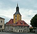 Town's church
 -
 Church in Rathewalde
 -
The Amsel Falls near Rathewalde
-
Shelter on the Hockstein in the Saxon Switzerland National Park


.jpg)
See also
[edit | edit source]- Hohnstein Castle (Saxon Switzerland)
- Schwarzbach Railway
- Goßdorf-Kohlmühle railway station
- Ulbersdorf railway station
References
[edit | edit source]- ^ Gewählte Bürgermeisterinnen und Bürgermeister im Freistaat Sachsen, Stand: 17. Juli 2022, Statistisches Landesamt des Freistaates Sachsen.
- ^ Lua error in Module:Citation/CS1/Configuration at line 2172: attempt to index field '?' (a nil value).
- ^ a b c Lua error in Module:Citation/CS1/Configuration at line 2172: attempt to index field '?' (a nil value).
External links
[edit | edit source]Error creating thumbnail: File missing Media related to Lua error in Module:Commons_link at line 62: attempt to index field 'wikibase' (a nil value). at Wikimedia Commons
- Newsreel WK2 from a private archive: http://www.archiv-akh.de/filme#1549 (Material Nr 1966, Time 10:17:28)
Lua error in Module:Authority_control at line 153: attempt to index field 'wikibase' (a nil value).