Haut-Folin
Jump to navigation
Jump to search
| Haut-Folin | |
|---|---|
 | |
| Highest point | |
| Elevation | 901 m (2,956 ft) |
| Coordinates | Lua error in Module:Coordinates at line 489: attempt to index field 'wikibase' (a nil value). |
| Geography | |
Lua error in Module:Location_map at line 411: Malformed coordinates value.
| |
| Location | Saône-et-Loire, France |
| Parent range | Morvan |
Haut-Folin (French pronunciation: [o fɔlɛ̃]) in the Saône-et-Loire department is at 901 m the highest point in the region of Burgundy in France. It is the summit of the Morvan mountain range.
It forms part of the drainage divide between the Seine and Loire rivers.
It is located in the commune of Saint-Prix.
There is a 40 km of cross-country skiing ski resort.
-
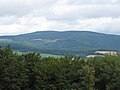 Haut folin view from Mont Beuvray
 -
 Television relay station

.jpg)
This Saône-et-Loire geographical article is a stub. You can help Wikipedia by expanding it. |