Getargel
Jump to navigation
Jump to search
Lua error in Module:Coordinates at line 489: attempt to index field 'wikibase' (a nil value).
Getragel
Գետարգել | |
|---|---|
| Dzagavank Monastery in Getargel Dzagavank Monastery in Getargel | |
| Lua error in Module:Location_map at line 411: Malformed coordinates value. | |
| Coordinates: Lua error: callParserFunction: function "#coordinates" was not found. | |
| Country | Armenia |
| Marz (Province) | Kotayk |
| Population (2011 census) | |
• Total | 795 |
| Time zone | UTC+4 ( ) |
Getargel (Armenian: Գետարգել), formerly known as Radiokayanin kits (ռադիոկայանին կից), or SMO, is a village in the Kotayk Province of Armenia.
The Dzagavank Monastery, also known as the Surp Nshan Monastery of Getargel, is located on the village's southern outskirts. The monastery consists of two churches: the main church of Surp Nshan dating back to the 7th century, and the 13th-century two-story chapel. The monastic complex was entirely renovated between 2001 and 2004.
As of the 2011 census, the population of the village is 795.[1] In addition to Armenians, the village has a Kurdish population.[2]
Gallery
[edit | edit source]-
 Church of Surp Nshan of Dzagavank Monastery of the 7th century
 -
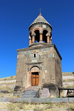 The 13th-century chapel at Dzagavank Monastery
_S._Nshan_General_View.JPG)
_S._Nshan_Bell_Tower_1.JPG)
_Monastery,_Arinj2.JPG)
See also
[edit | edit source]References
[edit | edit source]- ^ Kotayk population
- ^ Lua error in Module:Citation/CS1/Configuration at line 2172: attempt to index field '?' (a nil value).