Friesack
Jump to navigation
Jump to search
Friesack | |
|---|---|
 Museum and library | |
 Coat of arms | |
Location of Friesack
within Havelland district | |
| Lua error in Module:Infobox_mapframe at line 197: attempt to index field 'wikibase' (a nil value). | |
| Lua error in Module:Location_map at line 411: Malformed coordinates value. | |
| Coordinates: Lua error in Module:Coordinates at line 489: attempt to index field 'wikibase' (a nil value). | |
| Country | Germany |
| State | Brandenburg |
| District | Havelland |
| Municipal assoc. | Friesack |
| Subdivisions | 2 Ortsteile |
| Government | |
| • Mayor (2024–29) | Lothar Schneider[1] (SPD) |
| Area | |
• Total | 84.01 km2 (32.44 sq mi) |
| Elevation | 35 m (115 ft) |
| Population (Lua error in Module:Settlement_Wikidata at line 197: attempt to index field 'wikibase' (a nil value).)Lua error in Module:Settlement_Wikidata at line 197: attempt to index field 'wikibase' (a nil value). | |
• Total | Lua error in Module:Settlement_Wikidata at line 197: attempt to index field 'wikibase' (a nil value). |
| Time zone | UTC+01:00 (CET) |
| • Summer (DST) | UTC+02:00 (CEST) |
| Postal codes | 14662 |
| Dialling codes | 033235 |
| Vehicle registration | HVL |
| Website | www.amt-friesack.de |
Friesack (German pronunciation: [ˈfʁiːzak] <phonos file="De-Friesack.ogg"></phonos>; also Friesack/Mark) is a town in the Havelland district, in Brandenburg, in north-eastern Germany. It is situated 22 km (14 mi) northeast of Rathenow, and 25 km (16 mi) southwest of Neuruppin. It is known for its Mesolithic archaeological site.

History
[edit | edit source]During World War II, in September 1943, the Oflag 8 prisoner-of-war camp was relocated from Frauenberg to Wutzetz, present-day district of Friesack.[2] Polish, Greek, Bulgarian and Romanian officers were held in the camp before its dissolution in April 1945.[2]
Film shot in Friesack
[edit | edit source]- 1923 : Die Schlucht des Todes (The Ravine of Death) directed by Luciano Albertini and Albert-Francis Bertoni
Demography
[edit | edit source]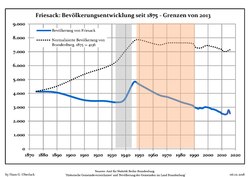
Friesack: Population development within the current boundaries (2017)[3] | ||||||||||||||||||||||||||||||||||||||||||||||||||||||||||||||||||||||||||||||||||||||||||||||||||||||||||||||||||||||||||||||||||||||
|
|
| ||||||||||||||||||||||||||||||||||||||||||||||||||||||||||||||||||||||||||||||||||||||||||||||||||||||||||||||||||||||||||||||||||||
Sons and daughters of the town
[edit | edit source]
- Emil Schallopp (1843-1919), chess master and writer
- Karsten Wettberg (born 1941), football coach
- Adalbert von Bredow (1814-1890), Prussian general
References
[edit | edit source]- ^ Landkreis Havelland Wahl der Bürgermeisterin / des Bürgermeisters. Retrieved 10 July 2024.
- ^ a b Lua error in Module:Citation/CS1/Configuration at line 2172: attempt to index field '?' (a nil value).
- ^ Detailed data sources are to be found in the Wikimedia Commons.Population Projection Brandenburg at Wikimedia Commons
Lua error in Module:Authority_control at line 153: attempt to index field 'wikibase' (a nil value).