File:MFD Airport Diagram.pdf
Jump to navigation
Jump to search

Size of this JPG preview of this PDF file: 390 × 599 pixels. Other resolutions: 156 × 240 pixels | 313 × 480 pixels | 806 × 1,237 pixels.
Original file (806 × 1,237 pixels, file size: 135 KB, MIME type: application/pdf)
This image should always reflect the most recent version. Feel free to update it when needed.
|
Summary
| Description |
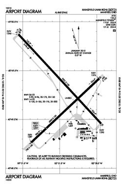
English: Mansfield Lahm Regional Airport Diagram |
| Date | |
| Source | Airport Diagram |
| Author | Federal Aviation Administration |
Licensing
This image or file is a work of a Federal Aviation Administration employee, taken or made as part of that person's official duties. As a work of the U.S. federal government, the image is in the public domain in the United States.
|
 |
File history
Click on a date/time to view the file as it appeared at that time.
| Date/Time | Thumbnail | Dimensions | User | Comment | |
|---|---|---|---|---|---|
| current | 23:00, 3 August 2024 |  | 806 × 1,237 (135 KB) | wikimediacommons>痛 | Update to the latest version |
File usage
The following page uses this file: