Earle's Chapel, Texas
Jump to navigation
Jump to search
Earle's Chapel, Texas | |
|---|---|
| Lua error in Module:Location_map at line 411: Malformed coordinates value. | |
| Coordinates: Lua error in Module:Coordinates at line 489: attempt to index field 'wikibase' (a nil value). | |
| Country | United States |
| State | Texas |
| County | Cherokee |
| Elevation | 515 ft (157 m) |
| Time zone | UTC-6 (Central (CST)) |
| • Summer (DST) | UTC-5 (CDT) |
| Area codes | 430, 903 |
| GNIS feature ID | 1373519[1] |
Earle's Chapel is an unincorporated community in Cherokee County, located in the U.S. state of Texas.[1] It is located west-southwest of Jacksonville, off U.S. Highway 79.
Government
[edit | edit source]Earle's Chapel and the surrounding area are served by Station #1 of its own Volunteer Fire Department.[2]
Education
[edit | edit source]The Earle's Chapel area is served by the Jacksonville Independent School District.
References
[edit | edit source]- ^ a b Lua error in Module:Citation/CS1/Configuration at line 2172: attempt to index field '?' (a nil value).
- ^ "Contact Us" Archived May 27, 2018, at the Wayback Machine, earleschapelvfd.org. Retrieved 2018-05-26.
Municipalities and communities of Cherokee County, Texas, United States | ||
|---|---|---|
| Cities | 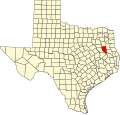 | |
| Towns | ||
| CDP | ||
| Other communities | ||
| Ghost towns | ||
| Footnotes | ‡This populated place also has portions in an adjacent county or counties | |
Lua error in Module:Authority_control at line 153: attempt to index field 'wikibase' (a nil value).
 | This article about a location in Cherokee County, Texas is a stub. You can help Wikipedia by expanding it. |