Doi Ang Khang
| Doi Ang Khang | |
|---|---|
| File:Le parc de Doi Angkhang.png Doi Ang Khang park | |
| Highest point | |
| Elevation | 1,400 m (4,600 ft) |
| Coordinates | Lua error in Module:Coordinates at line 489: attempt to index field 'wikibase' (a nil value). |
| Geography | |
Lua error in Module:Location_map at line 411: Malformed coordinates value.
| |
| Location | Ban Khum Village, Mu 5, Mae Ngon Sub district, Amphoe Fang, Chiang Mai Province |
| Parent range | Daen Lao Range |
| Geology | |
| Mountain type | Limestone |
| Climbing | |
| Easiest route | drive |
Doi Ang Khang (Thai: ดอยอ่างขาง) is a mountain in Fang District, Chiang Mai Province, Thailand. It is part of the Daen Lao Range that straddles both sides of the Burmese-Thai border. It is the site of an agricultural station, the first research station set up by King Bhumibol Adulyadej in 1969.[1] The peak of Doi Ang Khang is 1,928 metres (6,325 ft) above sea level, and the agricultural station covers an area of 1,989 rai (318 ha).
Climate
[edit | edit source]The temperature average is 19.6 °C. The highest temperatures range from 35-38 °C in April. The lowest temperature recorded is -3 °C in January. The rainfall average is 1906 mm per year.
| Climate data for Doi Ang Khang (1981–2010) | |||||||||||||
|---|---|---|---|---|---|---|---|---|---|---|---|---|---|
| Month | Jan | Feb | Mar | Apr | May | Jun | Jul | Aug | Sep | Oct | Nov | Dec | Year |
| Mean daily maximum °C (°F) | 20.0 (68.0) |
23.0 (73.4) |
26.2 (79.2) |
27.4 (81.3) |
24.3 (75.7) |
24.0 (75.2) |
22.9 (73.2) |
22.4 (72.3) |
22.6 (72.7) |
21.6 (70.9) |
19.8 (67.6) |
18.7 (65.7) |
22.7 (72.9) |
| Daily mean °C (°F) | 16.8 (62.2) |
19.3 (66.7) |
22.2 (72.0) |
23.2 (73.8) |
21.1 (70.0) |
21.0 (69.8) |
20.3 (68.5) |
19.9 (67.8) |
20.0 (68.0) |
19.0 (66.2) |
17.2 (63.0) |
15.9 (60.6) |
19.6 (67.3) |
| Mean daily minimum °C (°F) | 13.0 (55.4) |
15.0 (59.0) |
17.5 (63.5) |
18.6 (65.5) |
17.6 (63.7) |
17.8 (64.0) |
17.7 (63.9) |
17.7 (63.9) |
17.5 (63.5) |
16.8 (62.2) |
14.3 (57.7) |
12.6 (54.7) |
16.3 (61.3) |
| Average rainfall mm (inches) | 18.8 (0.74) |
10.5 (0.41) |
17.7 (0.70) |
96.1 (3.78) |
279.3 (11.00) |
179.0 (7.05) |
321.2 (12.65) |
403.3 (15.88) |
297.9 (11.73) |
246.6 (9.71) |
34.4 (1.35) |
1.3 (0.05) |
1,906.2 (75.05) |
| Average relative humidity (%) | 63.8 | 46.8 | 45.9 | 58.8 | 79.7 | 84.5 | 87.5 | 90.7 | 88.5 | 88.4 | 76.7 | 72.9 | 73.7 |
| Mean monthly sunshine hours | 272.8 | 240.1 | 275.9 | 243.0 | 198.4 | 159.0 | 161.2 | 158.1 | 183.0 | 198.4 | 249.0 | 251.1 | 2,590 |
| Percentage possible sunshine | 80 | 76 | 75 | 65 | 49 | 40 | 40 | 40 | 50 | 56 | 75 | 75 | 59 |
| Source 1: Thai Meteorological Department[2] | |||||||||||||
| Source 2: Office of Water Management and Hydrology, Royal Irrigation Department (sunshine)[3] | |||||||||||||
Ang Khang Royal Agricultural Station
[edit | edit source]The agricultural station researches and cultivates temperate climate fruits, flowers, and vegetables. At present, the station has more than 12 species of temperate fruits such as raspberries, peaches, plums, kiwis, and strawberries, and more than 60 species of vegetables such as carrots, Brussels sprouts, and peas, and more than 50 species of temperate flowers such as carnations and roses.
Gallery
[edit | edit source]-

-
-
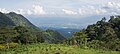 Fang Valley from one of the two access roads to Doi Ang Khang
 -
 Ang Khang Royal Agricultural Station


References
[edit | edit source]- ^ Lua error in Module:Citation/CS1/Configuration at line 2172: attempt to index field '?' (a nil value).
- ^ Lua error in Module:Citation/CS1/Configuration at line 2172: attempt to index field '?' (a nil value).
- ^ Lua error in Module:Citation/CS1/Configuration at line 2172: attempt to index field '?' (a nil value).
External links
[edit | edit source]
- File:Wikivoyage-Logo-v3-icon.svg Doi Ang Khang travel guide from Wikivoyage
- Tourism Authority of Thailand: Doi Angkhang
