Daaden
Jump to navigation
Jump to search
Daaden | |
|---|---|
|
Coat of arms of Daaden Coat of arms | |
Location of Daaden
within Altenkirchen district 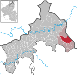 | |
| Lua error in Module:Infobox_mapframe at line 197: attempt to index field 'wikibase' (a nil value). | |
| Lua error in Module:Location_map at line 411: Malformed coordinates value. | |
| Coordinates: Lua error in Module:Coordinates at line 489: attempt to index field 'wikibase' (a nil value). | |
| Country | Germany |
| State | Rhineland-Palatinate |
| District | Altenkirchen |
| Municipal assoc. | Daaden-Herdorf |
| Government | |
| • Mayor (2019–24) | Walter Strunk[1] |
| Area | |
• Total | 19.58 km2 (7.56 sq mi) |
| Elevation | 427 m (1,401 ft) |
| Population (Lua error in Module:Settlement_Wikidata at line 197: attempt to index field 'wikibase' (a nil value).)Lua error in Module:Settlement_Wikidata at line 197: attempt to index field 'wikibase' (a nil value). | |
• Total | Lua error in Module:Settlement_Wikidata at line 197: attempt to index field 'wikibase' (a nil value). |
| Time zone | UTC+01:00 (CET) |
| • Summer (DST) | UTC+02:00 (CEST) |
| Postal codes | 57567 |
| Dialling codes | 02743 |
| Vehicle registration | AK |
| Website | www.daaden.org |
Daaden (German pronunciation: [ˈdaːdn̩]) is a town in the district of Altenkirchen, Rhineland-Palatinate, Germany. It is situated in the Westerwald, approx. 15 km south-west of Siegen.
Daaden is the seat of the Verbandsgemeinde ("collective municipality") Daaden-Herdorf.
Traffic
[edit | edit source].jpg)
Daaden is located on the end of the Betzdorf -Daaaden railway line (RB97).
References
[edit | edit source]- ^ Direktwahlen 2019, Landkreis Altenkirchen, Landeswahlleiter Rheinland-Pfalz, accessed 3 August 2021.
External links
[edit | edit source]- Official website (German)
Wikimedia Commons has media related to Daaden.
Lua error in Module:Authority_control at line 153: attempt to index field 'wikibase' (a nil value).