Champier
Jump to navigation
Jump to search
You can help expand this article with text translated from the corresponding article in français. (December 2009) Click [show] for important translation instructions.
|
Champier | |
|---|---|
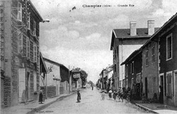 The main road in 1922 | |
| Lua error in Module:Infobox_mapframe at line 197: attempt to index field 'wikibase' (a nil value). | |
| Lua error in Module:Location_map at line 411: Malformed coordinates value. | |
| Coordinates: Lua error in Module:Coordinates at line 489: attempt to index field 'wikibase' (a nil value). | |
| Country | France |
| Region | Auvergne-Rhône-Alpes |
| Department | Isère |
| Arrondissement | Vienne |
| Canton | Bièvre |
| Government | |
| • Mayor (2020–2026) | Sébastien Laroche[1] |
Area 1 | 14.43 km2 (5.57 sq mi) |
| Population (Lua error in Module:Settlement_Wikidata at line 197: attempt to index field 'wikibase' (a nil value).)Lua error in Module:Settlement_Wikidata at line 197: attempt to index field 'wikibase' (a nil value). | Lua error in Module:Settlement_Wikidata at line 197: attempt to index field 'wikibase' (a nil value). |
| Time zone | UTC+01:00 (CET) |
| • Summer (DST) | UTC+02:00 (CEST) |
| INSEE/Postal code | 38069 /38260 |
| Elevation | 470–631 m (1,542–2,070 ft) (avg. 507 m or 1,663 ft) |
| 1 French Land Register data, which excludes lakes, ponds, glaciers > 1 km2 (0.386 sq mi or 247 acres) and river estuaries. | |
Champier (French pronunciation: [ʃɑ̃pje]) is a commune in the Isère department in southeastern France.[2]
Population
[edit | edit source]| Year | Pop. | ±% p.a. |
|---|---|---|
| 1968 | 741 | — |
| 1975 | 757 | +0.31% |
| 1982 | 832 | +1.36% |
| 1990 | 873 | +0.60% |
| 1999 | 967 | +1.14% |
| 2007 | 1,120 | +1.85% |
| 2012 | 1,302 | +3.06% |
| 2017 | 1,400 | +1.46% |
| Source: INSEE[3] | ||
See also
[edit | edit source]References
[edit | edit source]- ^ Lua error in Module:Citation/CS1/Configuration at line 2172: attempt to index field '?' (a nil value).
- ^ INSEE commune file
- ^ Population en historique depuis 1968, INSEE
Wikimedia Commons has media related to [[commons:Lua error in Module:WikidataIB at line 506: attempt to index field 'wikibase' (a nil value).|Lua error in Module:WikidataIB at line 506: attempt to index field 'wikibase' (a nil value).]].
Lua error in Module:Authority_control at line 153: attempt to index field 'wikibase' (a nil value).
This Arrondissement of Vienne geographical article is a stub. You can help Wikipedia by expanding it. |