Ben Stack
| Ben Stack | |
|---|---|
| Beinn Stac | |
| File:Ben Stack - geograph.org.uk - 820662.jpg Ben Stack | |
| Highest point | |
| Elevation | 721 m (2,365 ft) |
| Prominence | 532 m (1,745 ft) |
| Listing | Graham, Marilyn |
| Coordinates | Lua error in Module:Coordinates at line 489: attempt to index field 'wikibase' (a nil value). |
| Naming | |
| English translation | Pinnacle hill |
| Language of name | Scottish Gaelic |
| Pronunciation | /ˌbɛn ˈstæk/ |
| Geography | |
Lua error in Module:Location_map at line 411: Malformed coordinates value.
| |
| OS grid | NC269423 |
| Topo map | OS Landranger 9 |
| Climbing | |
| Easiest route | Walk |
Ben Stack (Scottish Gaelic: Beinn Stac) is a mountain in Sutherland, in the northwest of Scotland. It is 721 m (2,365 ft) high. It lies southeast of Laxford Bridge and northwest of Loch More along the A838 road, and just west of Loch Stack.
It is regarded as a moderately easy walk for walkers and hikers due to its overall height and its accessibility from the A838 road. It is most commonly climbed from the southeast, following the long eastern ridge of Leathad na Stioma. A slightly steeper alternative comes from the northwestern side, starting from near Lochstack Lodge. These starting points are both located on the A838 road, thus a traverse is possible.
On 6 August 2005 former U.K. Foreign Secretary Robin Cook died after collapsing with a heart attack whilst walking down from the summit.[1]
See also
[edit | edit source]References
[edit | edit source]- ^ Lua error in Module:Citation/CS1/Configuration at line 2172: attempt to index field '?' (a nil value).
Picture gallery
[edit | edit source]Click on image to view full size
-
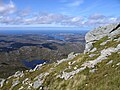 Looking west from Ben Stack
 -
 The Ben Stack summit ridge
 -
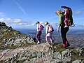 Walking on Ben Stack


External links
[edit | edit source]- A walk up Ben Stack Archived 2005-10-19 at the Wayback Machine with photos.