Bee, Minnesota
Jump to navigation
Jump to search
Bee | |
|---|---|
| Lua error in Module:Location_map at line 411: Malformed coordinates value. | |
| Coordinates: Lua error in Module:Coordinates at line 489: attempt to index field 'wikibase' (a nil value). | |
| Country | United States |
| State | Minnesota |
| County | Houston County |
| Township | Wilmington Township |
| Elevation | 906 ft (276 m) |
| Time zone | UTC-6 (Central (CST)) |
| • Summer (DST) | UTC-5 (CDT) |
| ZIP code | 55974 |
| Area code | 507 |
| GNIS feature ID | 654594[1] |
Bee is an unincorporated community in Wilmington Township, Houston County, Minnesota, United States.
The community is located at the junction of Bee Hill Drive and Oakland Drive.
Bee Creek–Waterloo Creek flows through the community. Nearby places in Minnesota include Spring Grove, Wilmington, Caledonia, and Eitzen. Nearby places in Iowa include Dorchester and Waterloo Creek Wildlife Management Area.
First named Bergen, Bee had a post office from 1891 to 1905. At one time, Bee had a flour mill, a store, a creamery, and a station on the former Chicago, Milwaukee and St. Paul Railroad.
References
[edit | edit source]- ^ Lua error in Module:Citation/CS1/Configuration at line 2172: attempt to index field '?' (a nil value).
External links
[edit | edit source]Municipalities and communities of Houston County, Minnesota, United States | ||
|---|---|---|
| Cities | 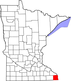 | |
| Townships | ||
| Unincorporated communities | ||
| Indian reservation | ||
| Footnotes | ‡This populated place also has portions in an adjacent county or counties | |
Lua error in Module:Authority_control at line 153: attempt to index field 'wikibase' (a nil value).