Addlebrough
Jump to navigation
Jump to search
| Addlebrough | |
|---|---|
| File:View of Addlebrough framed by old barns (geograph 2622551).jpg Addlebrough from the north | |
| Highest point | |
| Elevation | 481 m (1,578 ft) |
| Prominence | 94 m |
| Coordinates | Lua error in Module:Coordinates at line 489: attempt to index field 'wikibase' (a nil value). |
| Geography | |
Lua error in Module:Location_map at line 411: Malformed coordinates value.
| |
| Location | North Yorkshire, England |
| OS grid | SD945881 |
Addlebrough is a fell in Wensleydale, North Yorkshire, England. It is 481 m (1,578 ft) high.
Bronze Age inhabitants built homes and enclosures on the fell's southern slopes.[1]
Gallery
[edit | edit source]-
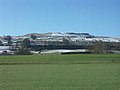 Addlebrough in winter, viewed from Askrigg Bottoms
 -
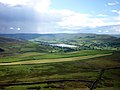 Semer Water from Addlebrough


.jpg)
References
[edit | edit source]- General
- Addlebrough – My Yorkshire Dales
Wikimedia Commons has media related to [[commons:Lua error in Module:WikidataIB at line 506: attempt to index field 'wikibase' (a nil value).|Lua error in Module:WikidataIB at line 506: attempt to index field 'wikibase' (a nil value).]].