Vogtei, Thuringia
Jump to navigation
Jump to search
Vogtei | |
|---|---|
 Coat of arms | |
Location of Vogtei
within Unstrut-Hainich-Kreis district 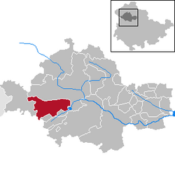 | |
| Lua error in Module:Infobox_mapframe at line 197: attempt to index field 'wikibase' (a nil value). | |
| Lua error in Module:Location_map at line 411: Malformed coordinates value. | |
| Coordinates: Lua error in Module:Coordinates at line 489: attempt to index field 'wikibase' (a nil value). | |
| Country | Germany |
| State | Thuringia |
| District | Unstrut-Hainich-Kreis |
| Subdivisions | 3 villages (Ortsteile) |
| Area | |
• Total | 49.57 km2 (19.14 sq mi) |
| Elevation | 227 m (745 ft) |
| Population (Lua error in Module:Settlement_Wikidata at line 197: attempt to index field 'wikibase' (a nil value).)Lua error in Module:Settlement_Wikidata at line 197: attempt to index field 'wikibase' (a nil value). | |
• Total | Lua error in Module:Settlement_Wikidata at line 197: attempt to index field 'wikibase' (a nil value). |
| Time zone | UTC+01:00 (CET) |
| • Summer (DST) | UTC+02:00 (CEST) |
| Postal codes | 99986 |
| Dialling codes | 03601 |
| Vehicle registration | UH |
| Website | www.gemeinde-vogtei.de |
Vogtei (German pronunciation: [foːkˈtaɪ] <phonos file="De-Vogtei.ogg"></phonos>) is a municipality in the Unstrut-Hainich-Kreis district of Thuringia, Germany. It was formed on 31 December 2012 by the merger of the former municipalities of Langula, Niederdorla, and Oberdorla. The closest town and the only one that it borders is Mühlhausen northerly. The Hainich National Park is situated westerly.
Geographical centre of Germany
[edit | edit source]One of the possible geographical centres of Germany lies in Vogtei; there is a plaque at Lua error: callParserFunction: function "#coordinates" was not found., c. 500 m (1,600 ft) to the north of the centre of Niederdorla.
See also
[edit | edit source]External links
[edit | edit source]References
[edit | edit source]
Lua error in Module:Authority_control at line 153: attempt to index field 'wikibase' (a nil value).