Jackson, Alabama
Jackson | |
|---|---|
 Brooke rifle in front of the Jackson City Hall | |
| Nickname: The Pine City | |
 Location of Jackson in Clarke County, Alabama. | |
| Coordinates: Lua error in Module:Coordinates at line 489: attempt to index field 'wikibase' (a nil value).[1] | |
| Country | United States |
| State | Alabama |
| County | Clarke |
| Area | |
• Total | 15.83 sq mi (41.00 km2) |
| • Land | 15.64 sq mi (40.50 km2) |
| • Water | 0.19 sq mi (0.50 km2) |
| Elevation | 279 ft (85 m) |
| Population (2020) | |
• Total | 4,748 |
| • Density | 303.6/sq mi (117.22/km2) |
| Time zone | UTC-6 (Central (CST)) |
| • Summer (DST) | UTC-5 (CDT) |
| ZIP codes | 36501, 36515, 36545 |
| Area code | 251 |
| FIPS code | 01-38152 |
| GNIS feature ID | 2404775[1] |
| Website | cityofjacksonal |


Jackson is a city in Clarke County, Alabama, United States. The population was 4,748 at the 2020 census.[3] It was one of three wet settlements in an otherwise-dry county.[4]
Geography
[edit | edit source]Jackson is located along the western border of Clarke County at coordinates Lua error: callParserFunction: function "#coordinates" was not found., on a rise overlooking east bank of the Tombigbee River. According to the U.S. Census Bureau, the city has a total area of 15.8 square miles (41.0 km2), of which 15.6 square miles (40.5 km2) is land and 0.19 square miles (0.5 km2), or 1.21%, is water.[5]
Jackson sits across the Tombigbee River from Washington County, Alabama.
Climate
[edit | edit source]| Climate data for Jackson, Alabama, 1991–2020 normals, extremes 1965–present | |||||||||||||
|---|---|---|---|---|---|---|---|---|---|---|---|---|---|
| Month | Jan | Feb | Mar | Apr | May | Jun | Jul | Aug | Sep | Oct | Nov | Dec | Year |
| Record high °F (°C) | 83 (28) |
84 (29) |
88 (31) |
95 (35) |
96 (36) |
103 (39) |
104 (40) |
104 (40) |
99 (37) |
98 (37) |
89 (32) |
86 (30) |
104 (40) |
| Mean maximum °F (°C) | 76.0 (24.4) |
78.5 (25.8) |
84.0 (28.9) |
86.6 (30.3) |
92.2 (33.4) |
95.3 (35.2) |
97.0 (36.1) |
96.6 (35.9) |
94.4 (34.7) |
89.1 (31.7) |
81.8 (27.7) |
77.9 (25.5) |
98.2 (36.8) |
| Mean daily maximum °F (°C) | 59.9 (15.5) |
64.1 (17.8) |
71.4 (21.9) |
77.5 (25.3) |
84.5 (29.2) |
89.5 (31.9) |
91.2 (32.9) |
91.2 (32.9) |
87.2 (30.7) |
78.7 (25.9) |
68.7 (20.4) |
61.9 (16.6) |
77.2 (25.1) |
| Daily mean °F (°C) | 47.9 (8.8) |
51.7 (10.9) |
58.4 (14.7) |
64.4 (18.0) |
72.1 (22.3) |
78.6 (25.9) |
80.8 (27.1) |
80.6 (27.0) |
76.2 (24.6) |
66.0 (18.9) |
55.7 (13.2) |
50.1 (10.1) |
65.2 (18.5) |
| Mean daily minimum °F (°C) | 36.0 (2.2) |
39.3 (4.1) |
45.4 (7.4) |
51.3 (10.7) |
59.7 (15.4) |
67.7 (19.8) |
70.5 (21.4) |
70.0 (21.1) |
65.3 (18.5) |
53.4 (11.9) |
42.6 (5.9) |
38.2 (3.4) |
53.3 (11.8) |
| Mean minimum °F (°C) | 20.1 (−6.6) |
23.4 (−4.8) |
28.3 (−2.1) |
36.3 (2.4) |
46.4 (8.0) |
59.1 (15.1) |
65.9 (18.8) |
63.5 (17.5) |
52.5 (11.4) |
36.9 (2.7) |
27.6 (−2.4) |
24.0 (−4.4) |
18.1 (−7.7) |
| Record low °F (°C) | 3 (−16) |
11 (−12) |
18 (−8) |
29 (−2) |
39 (4) |
48 (9) |
56 (13) |
57 (14) |
40 (4) |
28 (−2) |
18 (−8) |
6 (−14) |
3 (−16) |
| Average precipitation inches (mm) | 5.72 (145) |
5.46 (139) |
5.52 (140) |
4.74 (120) |
3.95 (100) |
6.26 (159) |
5.40 (137) |
5.17 (131) |
4.37 (111) |
3.75 (95) |
4.35 (110) |
5.52 (140) |
60.21 (1,527) |
| Average snowfall inches (cm) | 0.0 (0.0) |
0.0 (0.0) |
0.0 (0.0) |
0.0 (0.0) |
0.0 (0.0) |
0.0 (0.0) |
0.0 (0.0) |
0.0 (0.0) |
0.0 (0.0) |
0.0 (0.0) |
0.0 (0.0) |
0.0 (0.0) |
0.0 (0.0) |
| Average precipitation days (≥ 0.01 in) | 10.2 | 9.3 | 8.9 | 7.5 | 7.6 | 10.0 | 12.1 | 10.4 | 8.1 | 6.3 | 7.6 | 10.4 | 108.4 |
| Average snowy days (≥ 0.1 in) | 0.0 | 0.1 | 0.0 | 0.0 | 0.0 | 0.0 | 0.0 | 0.0 | 0.0 | 0.0 | 0.0 | 0.0 | 0.1 |
| Source 1: NOAA[6] | |||||||||||||
| Source 2: National Weather Service[7] | |||||||||||||
Demographics
[edit | edit source]| Census | Pop. | Note | %± |
|---|---|---|---|
| 1900 | 1,039 | — | |
| 1910 | 1,379 | 32.7% | |
| 1920 | 1,331 | −3.5% | |
| 1930 | 1,828 | 37.3% | |
| 1940 | 2,039 | 11.5% | |
| 1950 | 3,072 | 50.7% | |
| 1960 | 4,959 | 61.4% | |
| 1970 | 5,957 | 20.1% | |
| 1980 | 6,073 | 1.9% | |
| 1990 | 5,819 | −4.2% | |
| 2000 | 5,419 | −6.9% | |
| 2010 | 5,228 | −3.5% | |
| 2020 | 4,748 | −9.2% | |
| U.S. Decennial Census[8] 2013 Estimate[9] | |||
2020
[edit | edit source]| Race | Num. | Perc. |
|---|---|---|
| White | 2,379 | 50.11% |
| Black or African American | 2,154 | 45.37% |
| Native American | 20 | 0.42% |
| Asian | 36 | 0.76% |
| Pacific Islander | 1 | 0.02% |
| Other/Mixed | 112 | 2.36% |
| Hispanic or Latino | 46 | 0.98% |
As of the 2020 United States census, there were 4,748 people, 1,775 households, and 1,112 families residing in the city.
2010
[edit | edit source]At the 2010 census there were 5,228 people, 2,112 households, and 1,446 families living in the city. The population density was 334 inhabitants per square mile (129/km2). There were 2,426 housing units at an average density of 153.5 per square mile (59.3/km2). The racial makeup of the city was 54.9% White, 42.9% African American, 0.7% Native American, 0.4% Asian, 0.3% from other races, and 0.8% from two or more races. Hispanic or Latino of any race were 1.4%.[10]
Of the 2,112 households 28.4% had children under the age of 18 living with them, 46.6% were married couples living together, 17.9% had a female householder with no husband present, and 31.5% were non-families. 29.4% of households were one person and 10.8% were one person aged 65 or older. The average household size was 2.44 and the average family size was 3.00.
The age distribution was 25.1% under the age of 18, 6.9% from 18 to 24, 23.6% from 25 to 44, 26.8% from 45 to 64, and 17.5% 65 or older. The median age was 40.4 years. For every 100 females, there were 87.7 males. For every 100 females age 18 and over, there were 88.9 males.
The median household income was $32,917 and the median family income was $46,328. Males had a median income of $54,688 versus $29,483 for females. The per capita income for the city was $21,822. About 21.9% of families and 29.0% of the population were below the poverty line, including 37.4% of those under age 18 and 18.3% of those age 65 or over.
2000
[edit | edit source]At the 2000 census there were 5,419 people, 2,094 households, and 1,507 families living in the city. The population density was 358.7 inhabitants per square mile (138.5/km2). There were 2,341 housing units at an average density of 155.0 per square mile (59.8/km2). The racial makeup of the city was 60.42% White, 38.49% African American, 0.26% Native American, 0.37% Asian, 0.20% from other races, and 0.26% from two or more races. Hispanic or Latino of any race were 0.65%.[11]
Of the 2,094 households 34.0% had children under the age of 18 living with them, 53.5% were married couples living together, 15.8% had a female householder with no husband present, and 28.0% were non-families. 26.3% of households were one person and 12.2% were one person aged 65 or older. The average household size was 2.54 and the average family size was 3.08.
The age distribution was 26.6% under the age of 18, 8.1% from 18 to 24, 27.2% from 25 to 44, 22.5% from 45 to 64, and 15.5% 65 or older. The median age was 38 years. For every 100 females, there were 85.8 males. For every 100 females age 18 and over, there were 80.4 males.
The median household income was $34,806 and the median family income was $45,516. Males had a median income of $43,558 versus $21,125 for females. The per capita income for the city was $17,346. About 15.3% of families and 21.2% of the population were below the poverty line, including 27.9% of those under age 18 and 20.1% of those age 65 or over.
History
[edit | edit source]
Jackson was founded in 1816 and is named after President Andrew Jackson. Former names for the city include Pine Level and Republicville.
During the Civil War, a Confederate fort was established on the banks of the Tombigbee River. It was named Fort Carney and was positioned on Carney's Bluff just south of Jackson. The cannon that was on the bluff now sits in front of City Hall.[13]
Jackson has four sites listed on the National Register of Historic Places. They are the Jackson Historic District, Clarke Mills, Doit W. McClellan Lustron House, and J. P. McKee Lustron House.[14]
During World War II, a prisoner-of-war camp was built and operated holding 253 captured German soldiers on Ocre Avenue.[15] The camp was opened April 6, 1945, and closed March 12, 1946.[16] Many of the prisoners were members of the Afrika Korps.[16]
Economy
[edit | edit source]The economy of Jackson is driven by the timber industry. Packaging Corporation of America has a paper mill that is the largest employer located in the city.[17]
Education
[edit | edit source]- Coastal Alabama Community College
- Jackson Academy
- Jackson Middle School
- Jackson High School
- Jackson Intermediate
- Joe M. Gillmore Elementary
- Walker Springs Baptist Church
Notable people
[edit | edit source]- Ann Bedsole (born 1930), member of both houses of the Alabama State Legislature 1979-1995[18]
- Stew Bolen (1902–1969), former Major League Baseball player
- Antonio Chatman (born 1979), NFL wide receiver[19]
- Jimmy Outlaw (1913–2006), former Major League Baseball player
- Samaje Perine (born 1995), NFL Running-Back
- Ray Prim (1906–1995), former Major League Baseball pitcher, raised in Jackson
- Jamaal Pritchett (born 2003), NFL Wide Receiver
- John "Jabo" Starks (1938–2018), funk and blues drummer
- Travis and Bob, musical duo
References
[edit | edit source]- ^ a b c U.S. Geological Survey Geographic Names Information System: Jackson, Alabama
- ^ Lua error in Module:Citation/CS1/Configuration at line 2172: attempt to index field '?' (a nil value).
- ^ a b Lua error in Module:Citation/CS1/Configuration at line 2172: attempt to index field '?' (a nil value).
- ^ Lua error in Module:Citation/CS1/Configuration at line 2172: attempt to index field '?' (a nil value).
- ^ Lua error in Module:Citation/CS1/Configuration at line 2172: attempt to index field '?' (a nil value).
- ^ Lua error in Module:Citation/CS1/Configuration at line 2172: attempt to index field '?' (a nil value).
- ^ Lua error in Module:Citation/CS1/Configuration at line 2172: attempt to index field '?' (a nil value).
- ^ Lua error in Module:Citation/CS1/Configuration at line 2172: attempt to index field '?' (a nil value).
- ^ Lua error in Module:Citation/CS1/Configuration at line 2172: attempt to index field '?' (a nil value).
- ^ Lua error in Module:Citation/CS1/Configuration at line 2172: attempt to index field '?' (a nil value).
- ^ Lua error in Module:Citation/CS1/Configuration at line 2172: attempt to index field '?' (a nil value).
- ^ Lua error in Module:Citation/CS1/Configuration at line 2172: attempt to index field '?' (a nil value).
- ^ Lua error in Module:Citation/CS1/Configuration at line 2172: attempt to index field '?' (a nil value).
- ^ Lua error in Module:Citation/CS1/Configuration at line 2172: attempt to index field '?' (a nil value).
- ^ Lua error in Module:Citation/CS1/Configuration at line 2172: attempt to index field '?' (a nil value).
- ^ a b Clarke County Historical Marker, N31°31’53.6”W087°53’28.8”
- ^ Lua error in Module:Citation/CS1/Configuration at line 2172: attempt to index field '?' (a nil value).
- ^ Lua error in Module:Citation/CS1/Configuration at line 2172: attempt to index field '?' (a nil value).
- ^ Lua error in Module:Citation/CS1/Configuration at line 2172: attempt to index field '?' (a nil value).
External links
[edit | edit source]- City of Jackson official website
- Jackson Area Chamber of Commerce
- The South Alabamian, local newspaper covering Jackson and surrounding area
- Coastal Gateway Regional Economic Development Alliance
Municipalities and communities of Clarke County, Alabama, United States | ||
|---|---|---|
| Cities | 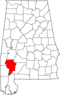 | |
| Towns | ||
| CDPs | ||
| Unincorporated communities | ||
| Ghost towns | ||
Lua error in Module:Authority_control at line 153: attempt to index field 'wikibase' (a nil value).