File:Urner Alpen.png
Jump to navigation
Jump to search

Size of this preview: 448 × 599 pixels. Other resolutions: 179 × 240 pixels | 359 × 480 pixels | 574 × 768 pixels | 766 × 1,024 pixels | 1,531 × 2,048 pixels | 2,626 × 3,512 pixels.
Original file (2,626 × 3,512 pixels, file size: 2.65 MB, MIME type: image/png)
| Description |
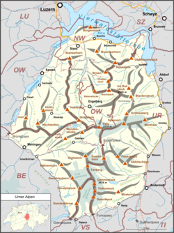
Deutsch: Lagekarte der Urner Alpen. |
| Date | |
| Source |
Own work Map was created using:
|
| Author | |
| Permission (Reusing this file) |
Map data (c) OpenStreetMap (and) contributors, CC-BY-SA |
This file is licensed under the Creative Commons Attribution-Share Alike 2.0 Generic license.
- You are free:
- to share – to copy, distribute and transmit the work
- to remix – to adapt the work
- Under the following conditions:
- attribution – You must give appropriate credit, provide a link to the license, and indicate if changes were made. You may do so in any reasonable manner, but not in any way that suggests the licensor endorses you or your use.
- share alike – If you remix, transform, or build upon the material, you must distribute your contributions under the same or compatible license as the original.
File history
Click on a date/time to view the file as it appeared at that time.
| Date/Time | Thumbnail | Dimensions | User | Comment | |
|---|---|---|---|---|---|
| current | 16:08, 26 August 2018 | | 2,626 × 3,512 (2.65 MB) | wikimediacommons>Pechristener | Lage des Brünigpass korrigiert |
File usage
The following page uses this file: