File:SRTS map PNG.png
Jump to navigation
Jump to search
Size of this preview: 305 × 600 pixels. Other resolutions: 122 × 240 pixels | 420 × 826 pixels.
Original file (420 × 826 pixels, file size: 89 KB, MIME type: image/png)
Summary
| Description |
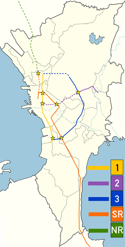
English: Strong Republic Transit System, was launched in 2003 to integrate rapid transit and railway lines in and around Metro Manila. This blank Metro Manila map has been used to create the map [1]. |
| Date | |
| Source | Own work |
| Author | Utnog La |
![[1]](https://en.wikipedia.org/wiki/File:BlankMap-MetroManila.png)
Licensing
I, the copyright holder of this work, hereby publish it under the following license:
This file is licensed under the Creative Commons Attribution-Share Alike 3.0 Unported license.
- You are free:
- to share – to copy, distribute and transmit the work
- to remix – to adapt the work
- Under the following conditions:
- attribution – You must give appropriate credit, provide a link to the license, and indicate if changes were made. You may do so in any reasonable manner, but not in any way that suggests the licensor endorses you or your use.
- share alike – If you remix, transform, or build upon the material, you must distribute your contributions under the same or compatible license as the original.
File history
Click on a date/time to view the file as it appeared at that time.
| Date/Time | Thumbnail | Dimensions | User | Comment | |
|---|---|---|---|---|---|
| current | 15:02, 19 July 2015 | | 420 × 826 (89 KB) | wikimediacommons>Abante86 | Part of PNR's orange line was stylized differently (Solis, C3 etc. never offered services) Purple line should be a dashed line. SRTS article should be about the initial program (which situation after the initial situation would be appropiate?? best to... |
File usage
The following page uses this file: