File:Relief Map of Novaya Zemlya.png
Jump to navigation
Jump to search

Size of this preview: 450 × 600 pixels. Other resolutions: 180 × 240 pixels | 600 × 800 pixels.
Original file (600 × 800 pixels, file size: 458 KB, MIME type: image/png)
Summary
| Description |
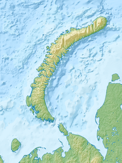
Русский: Архипелаг Новая Земля (Россия), физическая карта.
|
| Date | |
| Source |
|
| Author | Nzeemin |
Licensing
I, the copyright holder of this work, hereby publish it under the following license:
This file is licensed under the Creative Commons Attribution-Share Alike 3.0 Unported license.
- You are free:
- to share – to copy, distribute and transmit the work
- to remix – to adapt the work
- Under the following conditions:
- attribution – You must give appropriate credit, provide a link to the license, and indicate if changes were made. You may do so in any reasonable manner, but not in any way that suggests the licensor endorses you or your use.
- share alike – If you remix, transform, or build upon the material, you must distribute your contributions under the same or compatible license as the original.
File history
Click on a date/time to view the file as it appeared at that time.
| Date/Time | Thumbnail | Dimensions | User | Comment | |
|---|---|---|---|---|---|
| current | 19:13, 31 May 2015 | | 600 × 800 (458 KB) | wikimediacommons>Cmdrjameson | Compressed with pngout. Reduced by 164kB (26% decrease). |
File usage
The following 17 pages use this file:
- Belushya Bay
- Belushya Guba
- Glazov Glacier
- Gora Severny Nunatak
- Inostrantsev Glacier
- Krasino, Arkhangelsk Oblast
- Lake Lednikovoye (Novaya Zemlya)
- Mityushikha Bay
- Nordenskiöld Bay, Novaya Zemlya
- Nordenskiöld Glacier (Novaya Zemlya)
- Pan'kovo test range
- Pechora Sea
- Rogachevo (air base)
- User:Ty654/List of earthquakes from 1970-1974 exceeding magnitude 6+
- User:Ty654/List of earthquakes from 1975-1979 exceeding magnitude 6+
- Module:Location map/data/Russia Novaya Zemlya
- Module:Location map/data/Russia Novaya Zemlya/doc