
File:NorthAmerica-WaterDivides.png
Jump to navigation
Jump to search

Size of this preview: 600 × 600 pixels. Other resolutions: 240 × 240 pixels | 480 × 480 pixels | 900 × 900 pixels.

Original file (900 × 900 pixels, file size: 370 KB, MIME type: image/png)


|
This map image could be re-created using vector graphics as an SVG file. This has several advantages; see Commons:Media for cleanup for more information. If an SVG form of this image is available, please upload it and afterwards replace this template with
{{vector version available|new image name}}.It is recommended to name the SVG file “NorthAmerica-WaterDivides.svg”—then the template Vector version available (or Vva) does not need the new image name parameter. |
Summary
| Description |
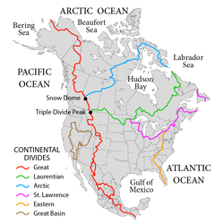
English: Map showing the major Continental divides of North America, following the style of File:NorthAmericaDivides.gif and intended as a replacement. Made using File:BlankMap-North America-Subdivisions.svg as a base map. Various maps and other sources consulted, such as: File:Ocean drainage.png, Drainage Basins, The Atlas of Canada, http://www.cec.org/atlas/files/watersheds/na_watersheds_en.jpg, and others. Note: the Eastern watershed boundary in the southern areas (orange line), and the St. Lawrence watershed boundary in the northern areas (magenta line) of this map more or less defined the Royal Proclamation's western boundaries. |
| Date | |
| Source |
This file was derived from: |
| Author | Pfly |


Licensing
I, the copyright holder of this work, hereby publish it under the following licenses:


This file is licensed under the Creative Commons Attribution-Share Alike 3.0 Unported license.
- You are free:
- to share – to copy, distribute and transmit the work
- to remix – to adapt the work
- Under the following conditions:
- attribution – You must give appropriate credit, provide a link to the license, and indicate if changes were made. You may do so in any reasonable manner, but not in any way that suggests the licensor endorses you or your use.
- share alike – If you remix, transform, or build upon the material, you must distribute your contributions under the same or compatible license as the original.

|
Permission is granted to copy, distribute and/or modify this document under the terms of the GNU Free Documentation License, Version 1.2 or any later version published by the Free Software Foundation; with no Invariant Sections, no Front-Cover Texts, and no Back-Cover Texts. A copy of the license is included in the section entitled GNU Free Documentation License. |
You may select the license of your choice.
File history
Click on a date/time to view the file as it appeared at that time.
| Date/Time | Thumbnail | Dimensions | User | Comment | |
|---|---|---|---|---|---|
| current | 02:47, 1 October 2019 | | 900 × 900 (370 KB) | wikimediacommons>Palaeozoic99 | Correct St. Lawrence |
File usage
The following 30 pages use this file:
- Atlantic seaboard watershed
- Canadian canoe routes
- Centennial Voyageur Canoe Pageant
- Central United States
- Chicago Portage
- Continental Divide of the Americas
- Continental divide
- Eastern Continental Divide
- Geography of North America
- Great Basin Divide
- Great Divide Basin
- Hudson Bay drainage basin
- Laurentian Divide
- List of rivers of the Americas
- North America
- Pacific Slope
- Pigeon River (Minnesota–Ontario)
- River
- Royal Proclamation of 1763
- Rupert's Land
- Snow Dome (Canada)
- St. Lawrence River Divide
- Timeline of Alberta history
- Triple Divide Peak (Montana)
- Triple divide
- Voyageurs
- Watersheds of North America
- Talk:Kensington Runestone
- Talk:List of lighthouses in the United States/Archive 1
- Talk:River/Archive 1
