File:Mapofqatar1849.jpg
Jump to navigation
Jump to search
Size of this preview: 600 × 600 pixels. Other resolutions: 240 × 240 pixels | 480 × 480 pixels | 856 × 856 pixels.
Original file (856 × 856 pixels, file size: 213 KB, MIME type: image/jpeg)
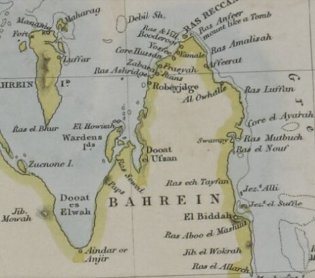
Summary
| Description |
English: An 1849 map which portrays Bahrain and present-day Qatar. |
| Date | |
| Source | http://www.qdl.qa/en/archive/81055/vdc_100023409892.0x000002 |
| Author | Walker, John |
| Other versions |
.jpg)
Licensing
| This file is made available under the Creative Commons CC0 1.0 Universal Public Domain Dedication. | |
| The person who associated a work with this deed has dedicated the work to the public domain by waiving all of their rights to the work worldwide under copyright law, including all related and neighboring rights, to the extent allowed by law. You can copy, modify, distribute and perform the work, even for commercial purposes, all without asking permission.
|
File history
Click on a date/time to view the file as it appeared at that time.
| Date/Time | Thumbnail | Dimensions | User | Comment | |
|---|---|---|---|---|---|
| current | 04:43, 9 September 2025 | | 856 × 856 (213 KB) | wikimediacommons>Elspamo4 | higher quality image that doesn't cut off "Bahrein" on the left side |
File usage
The following 26 pages use this file:
- 1717 Omani invasion of Bahrain
- 1981 Bahraini coup attempt
- 1990s uprising in Bahrain
- 2000s in Bahrain
- Al Bidda
- Awal
- Bahrain administrative reforms of the 1920s
- Bahrain and its Dependencies
- Bani Utbah invasion of Bahrain
- First Oil Well, Bahrain
- History of Bahrain
- History of Qatar
- Jabrids
- Jarwanid dynasty
- March Intifada
- Nasr Al-Madhkur
- National Union Committee
- Qatari–Bahraini War
- State Security Law in Bahrain
- Tylos
- Usfurids
- Uyunid dynasty
- User:༆/History of Asia templates
- Template:History of Bahrain
- Special:Badtitle/NS100:Bahrain
- Special:Badtitle/NS100:Bahrain/Topics