File:Map of Ontario DISTRICTS.svg
Jump to navigation
Jump to search
Original file (SVG file, nominally 340 × 330 pixels, file size: 83 KB)
Summary


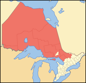

| Description | Map of Ontario showing which census divisions are districts |
| Date | |
| Source | Crop and trace of Image:Canada (geolocalisation).svg; trace of Image:Ontario subdivisions.PNG. |
| Author | Vidioman |
| Other versions | en:Image:District-tier-ontario.PNG |
.svg)


Licensing

|
I, the copyright holder of this work, release this work into the public domain. This applies worldwide. In some countries this may not be legally possible; if so: I grant anyone the right to use this work for any purpose, without any conditions, unless such conditions are required by law. |
File history
Click on a date/time to view the file as it appeared at that time.
| Date/Time | Thumbnail | Dimensions | User | Comment | |
|---|---|---|---|---|---|
| current | 11:30, 12 October 2007 | No thumbnail | 340 × 330 (83 KB) | wikimediacommons>Vidioman | {{Created with Inkscape}} {{Information |Description=DESCRIBE |Source=Crop and trace of Image:Canada (geolocalisation).svg; trace of [http://en.wikipedia.org/wiki/Image:Ontario_subdivisions.PNG Image:Ontario subdivisions.PNG]. |Date=12 October 2007 | |
.svg&action=edit&redlink=1)
File usage
The following 2 pages use this file:
