
File:Map Iran 1900-en.png
Jump to navigation
Jump to search
Size of this preview: 721 × 599 pixels. Other resolutions: 289 × 240 pixels | 578 × 480 pixels | 924 × 768 pixels | 1,096 × 911 pixels.


Original file (1,096 × 911 pixels, file size: 352 KB, MIME type: image/png)


|
This historical map image could be re-created using vector graphics as an SVG file. This has several advantages; see Commons:Media for cleanup for more information. If an SVG form of this image is available, please upload it and afterwards replace this template with
{{vector version available|new image name}}.It is recommended to name the SVG file “Map Iran 1900-en.svg”—then the template Vector version available (or Vva) does not need the new image name parameter. |
Summary
| Description |
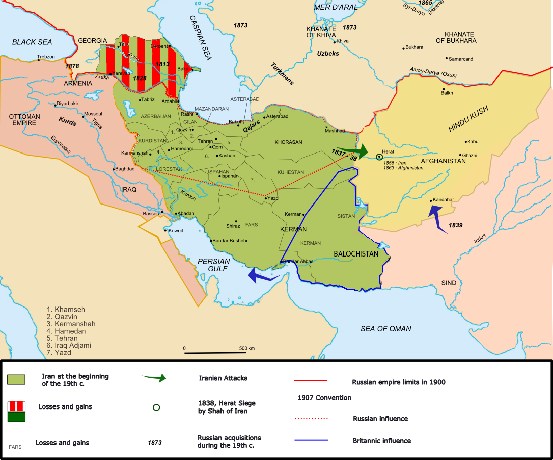
English: Iran circa 1900. Inspired by the Historical Atlas by Georges Duby, p. 211, map C, this map was made by Fabienkhan on 25 September 2006 using Inkscape and GIMP.
Français : L’Iran vers 1900. Inspirée par l’Atlas historique de Georges Duby, p. 211, carte C, cette carte a été conçue par Fabienkhan le 25 septembre 2006 à l’aide d’Inkscape et de GIMP. |
| Date | 24 September 2006 (original upload date) |
| Source | Own work |
| Author | Fabienkhan |
| Other versions | See also the French version: File:Map_Iran_1900-fr.png |

Licensing
I, the copyright holder of this work, hereby publish it under the following license:


This file is licensed under the Creative Commons Attribution-Share Alike 2.5 Generic, 2.0 Generic and 1.0 Generic license.
- You are free:
- to share – to copy, distribute and transmit the work
- to remix – to adapt the work
- Under the following conditions:
- attribution – You must give appropriate credit, provide a link to the license, and indicate if changes were made. You may do so in any reasonable manner, but not in any way that suggests the licensor endorses you or your use.
- share alike – If you remix, transform, or build upon the material, you must distribute your contributions under the same or compatible license as the original.

Note:
 Inspired by the Historical Atlas by Georges Duby, p. 211, map C, this map was made by Fabienkhan on 25 September 2006 with Inkscape and GIMP.
 Inspiré par l’Atlas historique de Georges Duby, p. 211, carte C, cette carte a été conçue par Fabienkhan le 25 septembre 2006 à l’aide d’Inkscape et de GIMP.
Description:
L’Iran vers 1900
Iran circa 1900
File history
Click on a date/time to view the file as it appeared at that time.
| Date/Time | Thumbnail | Dimensions | User | Comment | |
|---|---|---|---|---|---|
| current | 17:40, 6 August 2017 | | 1,096 × 911 (352 KB) | wikimediacommons>Oganesson007 | Added Kingdom of Kartli-Kakheti, deleted modern day Turkmenistan, which was never under Qajar's control. |
File usage
The following 27 pages use this file:
- Anglo-Russian Convention
- Erdoğan Iran poem controversy
- Great Game
- History of Azerbaijan
- History of Iran
- Iran
- Iranian nationalism
- Military history of Iran
- Qajar Iran
- Russia–United Kingdom relations
- Sphere of influence
- Territorial evolution of Russia
- Turkoman (ethnonym)
- User:Chickstarr404/Gather lists/14627 – Personal History - Desert Gardens by Vincent Sheehan
- User:Falcaorib/Afghanistan
- User:Falcaorib/Armenia, Azerbaijan and Georgia
- User:Falcaorib/Central Asia
- User:Falcaorib/Contemporary Empires (1800-2024 AD)
- User:Falcaorib/Iran
- User:Falcaorib/Turkey and Ottoman Empire
- User:Joelton Ivson/Gather lists/24351 – Geórgia
- User:Joelton Ivson/Gather lists/24359 – Os Persas
- User:Thecatcherintherye/Sandbox
- User talk:A Contemporary Nomad
- MyWiki:Graphics Lab/Images to improve/Archive/Apr 2008
- File talk:Map Iran 1900-en.png
- Special:Badtitle/NS100:Azerbaijan

