File:Map Byzantine Empire 1045.svg

Summary
| Description |
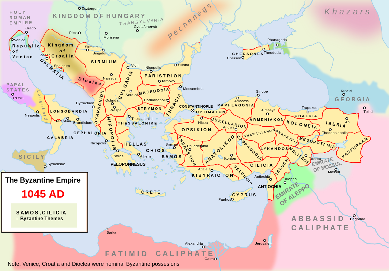
Català: L'imperi bizantí i els seus veïns l'any 1045. Inclou divisions administratives bizantines.
English: Own work. The Byzantine empire and its neighbours in 1045. Byzantine administrative divisions included.
Source> Stelian Brezeanu> O istorie a Imperiului Bizantin, Bucharest 1981. The map at page 110. Please write on the talk page if I misspelled the name of some themes. An available derivative work is a cropping showing only the central Balkans: :Image:Byzantine Macedonia 1045CE.svg. |
| Date | 10 December 2007 (original upload date) |
| Source | Own work |
| Author | Andrein at English Wikipedia |
| Other versions |
File:Map Byzantine Empire 1045.svg contains 2 translations.
Other related versions: []
|




|
This SVG file contains embedded text that can be translated into your language, using any capable SVG editor, text editor or the SVG Translate tool. For more information see: About translating SVG files. |


|
This file is translated using SVG <switch> elements. All translations are stored in the same file! Learn more.
For most Wikipedia projects, you can embed the file normally (without a To translate the text into your language, you can use the SVG Translate tool. Alternatively, you can download the file to your computer, add your translations using whatever software you're familiar with, and re-upload it with the same name. You will find help in Graphics Lab if you're not sure how to do this. |
Licensing

|
This work has been released into the public domain by its author, Andrein at English Wikipedia. This applies worldwide. In some countries this may not be legally possible; if so: Andrein grants anyone the right to use this work for any purpose, without any conditions, unless such conditions are required by law. |
File history
Click on a date/time to view the file as it appeared at that time.
| Date/Time | Thumbnail | Dimensions | User | Comment | |
|---|---|---|---|---|---|
| current | 16:06, 11 February 2024 | | 1,300 × 900 (428 KB) | wikimediacommons>Manlleus | File uploaded using svgtranslate tool (https://svgtranslate.toolforge.org/). Added translation for ca. |
File usage
The following 18 pages use this file:
- Byzantine–Georgian war (1028)
- Byzantine–Georgian wars
- Theme (Byzantine district)
- Timeline of Eastern Orthodoxy in Greece (717–1204)
- Talk:Byzantine Empire/Archive 10
- Talk:Narentines/Archive 2
- User:Falcaorib/Balkans maps
- User:Falcaorib/Bulgaria and North Macedonia
- User:Falcaorib/Greece and Byzantine Empire
- User:Falcaorib/Medieval Empires (1000-1100 AD)
- User:Falcaorib/Serbia, Yugoslavia and Albania
- User:Falcaorib/Turkey and Ottoman Empire
- User:Sasha l~enwiki/maps
- User:WildFields/sandbox
- User talk:Iberieli
- MyWiki:Featured picture candidates/Byzantine Empire in 1045
- MyWiki:Featured picture candidates/November-2008
- File talk:Map Byzantine Empire 1045.svg

