File:Kingdoms of Israel and Judah map 830.svg
Jump to navigation
Jump to search

Size of this PNG preview of this SVG file: 502 × 599 pixels. Other resolutions: 201 × 240 pixels | 402 × 480 pixels | 644 × 768 pixels | 858 × 1,024 pixels | 1,717 × 2,048 pixels | 720 × 859 pixels.
Original file (SVG file, nominally 720 × 859 pixels, file size: 96 KB)
 |
 This media file has been nominated for deletion since 7 February 2026. To discuss it, please visit the nomination page.
Do not remove this tag until the deletion nomination is closed. Reason for the nomination: Original research. Only source is to a map from Jewish Virtual Library which is not reliable. Also this map doesn't match the JVL map.
| ||
| |||

| Description |
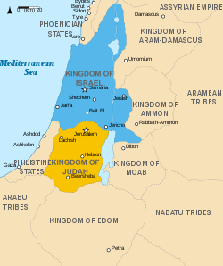
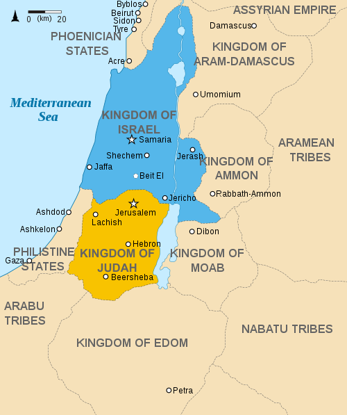
English: Approximate map showing the Kingdoms of Israel (blue) and Judah (orange), ancient Southern Levant borders and ancient cities such as Urmomium and Jerash. The map shows the region in the 9th century BCE. Italiano: Il regno di Giuda e quello di Israele nell'età del ferro (VIII secolo a.C.).
日本語: 紀元前830年代のユダ王国(黄色).
Русский: Царство Иудея 927 по 526 гг. до н. э. Отсюда иудеи были сосланы завоевателями в Вавилонский регион.
Bahasa Indonesia: Peta kerajaan-kerajaan di daerah tersebut pada abad 9 SM.
Simple English: The northern Kingdom of Israel and the Kingdom of Judah to the south.
Srpskohrvatski / српскохрватски: Karta Sjevernog i JUžnog Kraljevstva. Samarija je bila glavni grad Kraljevstva Izrael (plavo). 830-e pne.,.
Latviešu: Izraēlas un Jūdejas karalistes. Jūdejas karaliste (dzeltenā) ap 830. gadu p.m.ē. |
| Date | (UTC) |
| Source | http://www.jewishvirtuallibrary.org/map-of-israel-and-judah-733-bceTemplate:Failed verification |
| Author |
|
| Other versions |
[]
|




I, the copyright holder of this work, hereby publish it under the following licenses:


This file is licensed under the Creative Commons Attribution-Share Alike 3.0 Unported license.
- You are free:
- to share – to copy, distribute and transmit the work
- to remix – to adapt the work
- Under the following conditions:
- attribution – You must give appropriate credit, provide a link to the license, and indicate if changes were made. You may do so in any reasonable manner, but not in any way that suggests the licensor endorses you or your use.
- share alike – If you remix, transform, or build upon the material, you must distribute your contributions under the same or compatible license as the original.

|
Permission is granted to copy, distribute and/or modify this document under the terms of the GNU Free Documentation License, Version 1.2 or any later version published by the Free Software Foundation; with no Invariant Sections, no Front-Cover Texts, and no Back-Cover Texts. A copy of the license is included in the section entitled GNU Free Documentation License. |
You may select the license of your choice.
Original upload log
This image is a derivative work of the following images:
- File:Oldtidens_Israel_&_Judea.svg licensed with Cc-by-sa-3.0, GFDL
- 2010-01-30T16:10:36Z FinnWikiNo 726x868 (109641 Bytes) {{Information |Description={{en|1=Map showing the ancient levant borders and ancient cities such as [[Urmomium]] and [[Jerash]]. The map also shows the region in the 9th century BCE. Notice the coastal land of Philistia, from
Uploaded with derivativeFX
File history
Click on a date/time to view the file as it appeared at that time.
| Date/Time | Thumbnail | Dimensions | User | Comment | |
|---|---|---|---|---|---|
| current | 14:12, 1 October 2021 | | 720 × 859 (96 KB) | wikimediacommons>Sadopaul | File uploaded using svgtranslate tool (https://svgtranslate.toolforge.org/). Added translation for ko. |
File usage
The following 21 pages use this file:
- Ancient history
- Ancient history of the Negev
- Battle of Mount Zemaraim
- Battle of Zephath
- Commonwealth Theology
- Elijah
- History of the Jews and Judaism in the Land of Israel
- Jew (word)
- Judaism
- Kingdom of Israel (united monarchy)
- Solomon
- Transjordan (region)
- Talk:History of the Jews and Judaism in the Land of Israel/Archive 1
- Talk:Samaria
- Talk:Shechem
- User:DaWalda/Agricultural history of the Negev
- User:Falcaorib/Ancient Empires (4000-550 BC)
- User:Falcaorib/Israel and Palestine
- User:Kharbaan Ghaltaan/sandbox
- User:SomeGuyWhoRandomlyEdits/List of conflicts in the Near East
- MyWiki:Reliable sources/Noticeboard/Archive 241
